Category: News

Add your news
You can add news from your networks or groups through the website by becoming an author. Simply register as a member of the Generator, and then email Giovanni asking to become an author. He will then work with you to integrate your content into the site as effectively as possible.
Listen to the Generator News online

 
The Generator news service publishes articles on sustainable development, agriculture and energy as well as observations on current affairs. The news service is used on the weekly radio show, The Generator, as well as by a number of monthly and quarterly magazines. A podcast of the Generator news is also available.
As well as Giovanni’s articles it picks up the most pertinent articles from a range of other news services. You can publish the news feed on your website using RSS, free of charge.
 

  • Flooded Riverina towns still sodden and suffering

    Flooded Riverina towns still sodden and suffering

    Updated May 21, 2012 08:32:27

    More than two months after devastating floods swept through the Riverina, in southern New South Wales, some farmers and residents are still suffering.

    Several farms are still underwater and hundreds of families have been unable to return to their damaged homes.

    Many are waiting for insurance pay outs to repair their properties.

    Yenda farmer Mark Groat is one of those affected.

    After eight years of drought he got more water than he wished for. More than two months after the floods, parts of his farm are still underwater.

    “Oh, even local people are surprised there is still water around,” he said.

    Mr Groat has lost his rice crop and will not be able to plant wheat over the winter.

    It will be several months before he can even drive on the sodden paddock.

    The farm only received minor damage when the flood started in March, but the real problems came when water started coming up from blocked irrigation drains.

    “The fact it has been on so long is what we have to look at. That’s what’s done the damage, the length of time it’s been on,” he said.

    “So if they can look at getting it off a lot quicker, well that’d save us a lot.”

    Next door, fellow farmer Brad Taylor is surveying the damage to his cherry orchard.


    The flood waters destroyed 11,000 young cherry trees, worth $500,000.

    “It was devastating just to see it coming up day after day. It was just a feeling of helplessness,” he said.

    Mr Taylor says the damage to his property was also caused by water rising from the drains, several days after the peak of the flood.

    “It was that afternoon that water started coming out of the drainage system and continued to do so for a long time,” he said.

    A spokesman from Murrumbidgee irrigation declined to be interviewed, but released a statement saying the organisation would cooperate with any inquiry on how to improve planning and the response to the flood.

    More than 200 families have been unable to return to the damaged homes in the town of Yenda.

    Ninety-year-old resident Phyllis Mott says she is one of the lucky ones, but is still waiting for a payout from her insurance company.

    “At least I’m in my house, there’s a lot of poor unfortunates that are not in their house in Yenda,” she said.

    “They’re battling, and I know there are a lot more worse off than them but it doesn’t alter the fact that you’re in misery while you’re like this, when it shouldn’t be.

    “Why don’t they tell us whether they’re going to pay or not? But they won’t.”

    The new wing of the local pre-school opened only five weeks before the flood hit. It was not fully insured. Now, it’s damaged and unusable.

    Some locals believe the community would have been spared if floods gates outside the town had been opened to allow the water to flow away, instead of into residential areas.

    More than two months after floods spread across the Riverina, many people around Yenda want to know whether everything possible was done to protect their community.

    The long wait for insurance pay outs and repairs continues.

    Topics:floods, rice, irrigation, yenda-2681

    First posted May 21, 2012 07:58:31

  • Guatemala volcano belches ash, lava

    News 9 new results for volcanoes
    Guatemala volcano belches ash, lava
    Herald Sun
    THE Fuego volcano in Guatemala has begun shooting lava and columns of ash into the air, and authorities have raised the alert level in the area. The volcano overlooks the tourist city of Antigua and is one of Central America’s most active volcanoes.
    See all stories on this topic »

    Newsday

    Turrialba Under Yellow Alert
    Inside Costa Rica
    Comisión Nacional de Prevención de riesgos y Atención de Emergencias (CNE) announced a yellow alert for the Turrialba National Park, home to the Turrialba Volcano. The alert means the park will remain closed until further notice.
    See all stories on this topic »

    Inside Costa Rica
    National parks to give military families a free pass
    San Francisco Chronicle (blog)
    The latter include eight in Hawai’i, three of which charge entrance fees: Hawai’i Volcanoes and Haleakalā national parks and Pu’uhonua O Hōnaunau National Historical Park. “We all owe a debt to those who sacrifice so much to protect our country,”
    See all stories on this topic »

    San Francisco Chronicle (blog)
    Calling all geeks – and people who want to learn – to the triennial USGS Open
    InMenlo
    While most of the exhibit booths are decidedly geeky, each is staffed by scientists eager to pass on their knowledge about earthquakes, water quality, volcanoes, coastal and marine geology, mineral and energy resources, geography and the San Francisco
    See all stories on this topic »

    InMenlo

    Hike, explore & protect Kahuku
    Hawaii 24/7 (press release)
    Kahuku at Hawaii Volcanoes National Park’s Kahuku Unit in Ka’u. (Photo courtesy of Dave Boyle | NPS) Two adventurous programs offered by Hawaii Volcanoes National Park will introduce a captivating landscape, biodiversity and history of the park’s
    See all stories on this topic »
    Maui: Heaven on earth
    Lincoln Journal Star
    Most of all, it is a mountainous land, created by volcanoes, with two large ones standing tall. The doublet volcano eruptions overlapped, creating an isthmus that filled in to form the island. Trade winds flow across thousands of miles of empty Pacific
    See all stories on this topic »


    This once a day Google Alert is brought to you by Google.

    Delete this alert.
    Create another alert.
    Manage your alerts.

    Reply
    Forward
    Click here to Reply or Forward

    Ads – Why this ad?
    Australia’s Best Prices I Class E Class M Class
    512
    0% full
    Using 0 MB of your 10,248 MB
    ©2012 GoogleTerms & Privacy
    Last account activity: 28 minutes ago

    Details

    Ads – Why these ads?
    Terratest Pty Ltd

    Geotech & Environmental Drilling Sydney – Brisbane – Newcastle
    512
    Electricity for Business

    Find out the discount your business is eligible for, get a quote today
    512
    1.5 kw solar system

    Installed for $1490 great service fast turnaround, act now
    512
    Australian Stock Report

    Our Team will show you which Stocks to Buy & Sell Everyday – Free Trial
    512
    Ella Baché College

    Distance Learning Or Study On Campus. Mid Year Intake Starting
    512
  • Pollution teams with thunderclouds to warm atmosphere

    Pollution teams with thunderclouds to warm atmosphere

    Posted: 19 May 2012 05:28 PM PDT

    New simulation study shows that atmosphere warms when pollution intensifies storms. How much the warming effect of these clouds offsets the cooling that other clouds provide is not yet clear.

  • Flash floods are on the rise, while the budget to tackle them sinks

    Flash floods are on the rise, while the budget to tackle them sinks

    The Environment Agency has warned the UK to expect more floods but its advice seems to be falling on deaf ears

    Drowning World at Somerset House by photo artist Gideon Mendel : Floods in India

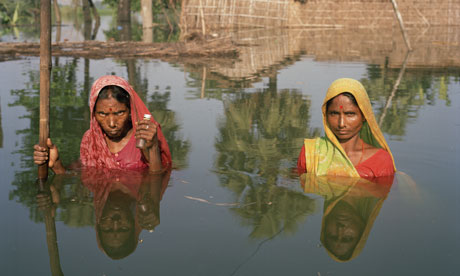
    The Drowning World exhibition currently on show at Somerset House in London shows scenes of devastation from around the globe, with the UK at risk too. Photograph: Gideon Mendel/Drowning World

    A moving new exhibition of photographs at Somerset House shows the human impact of flooding around the world over the past five years and provides an insight into how climate change may already be disrupting lives and livelihoods.

    The images from major flooding events in the UK, Pakistan, Australia and Thailand feature victims and survivors as they cope with the inundation of their homes and the aftermath. The photographer, Gideon Mendel, says his intention is “to depict them as individuals, not as nameless statistics”. He adds: “Coming from disparate parts of the world, their faces show us their linked vulnerability despite the vast differences in their lives and circumstances.”

    One of the most striking exhibits shows Margaret Clegg standing knee-deep in water in the living room of her house in Toll Bar, Doncaster, which was flooded when the River Don overtopped its banks in June 2007, following a record downpour.

    It is not clear to what extent, if any, climate change contributed to the occurrence or intensity of the summer 2007 floods in England and Northern Ireland, which cost the UK economy more than £3bn. A single extreme weather event cannot be definitely attributed to climate change, the influence of which can only be detected and measured through the analysis of statistical trends looking back over many decades. That means we will not be certain for many years to come about how flood risk is being affected.

    We know from basic physics that a warmer atmosphere can become more humid and holds more water vapour, theoretically increasing by about 7% for every extra centigrade degree. As a result climate change is expected to increase the intensity of the water cycle in many parts of the world, causing both more droughts and more floods.

    An analysis of UK weather trends between 1961 and 2006, during which the average temperature increased by about one centigrade degree, indicated that although our winters have not become significantly wetter, the number and severity of heavy rainfall events has increased. Meanwhile, summers have become drier and heavy summer downpours have decreased in all parts of the UK, except in north-east England, where some of the 2007 flooding occurred, and north Scotland.

    Climate change is expected to increase the risk of flooding in many parts of the UK. Projections published by the Department for Environment, Food and Rural Affairs (Defra) in 2009 suggested that, under a “medium emissions scenario”, overall winter precipitation should be higher in the 2080s, while summer rainfall should generally be lower, particularly in the south.

    The UK climate change risk assessment, published by Defra earlier this year, calculated that these potential trends mean the annual damage from coastal and river flooding in England and Wales could increase from about £1.2bn today to as much as £12bn in the worst case scenario over the next 80 years.

    Such an increase in the risk of damage would have major consequences, not least in terms of the affordability and availability of flood insurance for homes and businesses. Indeed, a crisis is already approaching, with insurers warning that from next year they may not continue to offer cover for 200,000 high-risk properties, exposed to a greater than 1 in 75 annual risk of flooding.

    Under an arrangement dating from 2000, insurance companies have subsidised flood cover for those in high-risk properties in return for greater government investment in coastal and river defences.

    At present, the Environment Agency is responsible for building and maintaining these defences. The agency has told the government it needs to increase its annual flood risk management budget by 9% by 2014-15. However, the House of Commons public accounts committee has highlighted government plans to reduce the agency’s flood risk funding by 10% over this period, and to shift more responsibility on to local authorities, even though their overall budgets are shrinking.

    Perhaps even more worrying is the neglect of the risk of flash flooding, caused by heavy downpours from often very localised storms that can inundate poorly drained areas, particularly in cities. Of the six million properties in the UK that are currently exposed to some degree of flood risk, four million are threatened by surface water flooding.

    Yet when the climate change risk assessment, upon which the government is basing its national adaptation plan, was published earlier this year, scientists warned that it was flawed because it had neglected possible future changes in flash flooding and other important threats.

    The assessment stated: “Whilst the number of properties at risk from surface water flooding is similar to the number at risk from tidal and river flooding, suitable information for analysis were not available at the time of writing this report.”

    In his official review of the assessment, Prof Martin Parry of the Grantham Institute for Climate Change at Imperial College expressed “concern that the risks identified do not necessarily represent the full range of potential risks, and the metrics were selected not on the basis of importance but on the availability of evidence”. However, Defra ignored his advice, surprisingly admitting that “the risks provided in this report are not intended to be a full range of risks”.

    This lack of attention to flash flooding could make it much more difficult to implement an important part of the government’s national planning policy framework, which states that local plans “should apply a sequential, risk-based approach to the location of development to avoid where possible flood risk to people and property and manage any residual risk, taking account of the impacts of climate change”.

    The likely increase in the risk of flooding is just one of the many ways in which unmitigated climate change will significantly affect homes and businesses, and will create larger societal and economic costs for the UK. These serious long-term impacts are often overlooked by those who complain about the cost of reducing emissions of greenhouse gases to limit the future impacts of climate change, yet they are just as important.

    • Bob Ward is policy and communications director at the Grantham Research Institute on Climate Change and the Environment at the London School of Economics and Political Science. The Drowning World exhibition is showing at Somerset House until 5 June.

  • Greenpeace should not choose green over peace

    Greenpeace should not choose green over peace

    The organisation’s support of a marine reserve in the Chagos islands displays a lack of regard for islanders wanting to return

    • Chagos islanders in Mauritius

      Chagos islanders in Mauritius. The Chagossians ‘are now dispersed around the Seychelles, Mauritius and England’. Photograph: Graeme Robertson

      Greenpeace International is a fine organisation. It uniquely combined the aims of promoting “peace” – including enhancing human rights – and, as an element of that, protecting the green (and blue) environment. Remember the dove with the olive branch, and the campaigns against US atmospheric nuclear bomb tests in the north Pacific and French underwater ones in the south Pacific. When the French secret service sank the Rainbow Warrior in Auckland harbour, the ship had been engaged in a humanitarian action: helping move some Polynesians from their homes, where they felt threatened by pollution and explosions.

      But Greenpeace seems to have mislaid the “peace” half of its mission. That has been evident for some time to anyone reading its current programme and priorities on its website. This grand drift was on show again at a conference organised by Amnesty International in Oxford last week, where Greenpeace International’s executive director, Kumi Naidoo – a man with a proud record of anti-apartheid campaigning – was to talk about human rights and protection of the environment. The context was a hot question about the possible return of the Chagos islanders to their home in mid-Indian Ocean, a British Overseas Territory from which they were all deported in 1971 to make way for a US military base on an atoll, Diego Garcia. That involved moving, it is said, several million tons of coral and destroying the quasi-pristine nature of the world’s biggest atoll, making it suitable for aircraft-carriers. The islanders are now dispersed around the Seychelles, Mauritius and England. Some of the islanders are happy with their UK/EU passports, others want to return home and have been seeking permission through the courts, the House of Lords, and – soon – the European court of human rights.

      The mandarins of Whitehall have worked for decades to block their repatriation claim, arguing first that the archipelago was uninhabited, and only occasionally visited by migrant labourers to pick coconuts. Then someone in Whitehall had another brilliant idea: declare Chagos as a vast Marine Protected Area (MPA). Unlike nearly all the new MPAs in Britain it would be “no-take” zone – fishing would be largely prohibited.

      This scheme was applauded by some influential non-governmental groups, in particular the Pew Foundation, the Royal Society of London and the Royal Society for the Protection of Birds (RSPB). It is said that the RSPB’s former international director, Alistair Gammell, now with Pew, persuaded Greenpeace UK to join the ecologists’ cheers of support for a no-take MPA. Greenpeace International, to its shame, went along with this, only adding, tardily, “provided the rights of the Chagossians are respected”. The Foreign Office says they have no rights, so that’s hunky-dory.

      As a matter of fact Greenpeace had already supported this idea long before – in 2005, writing: “The Chagos islands, which the [proposed] reserve bounds, are uninhabited and almost unpolluted and little affected by direct human impacts except fishing”. No mention, of course, of the several thousand military folks deployed there, whose main outdoor recreation is recreational marlin and tuna fishing.

      The Greenpeace UK letter of support asserted that no-take MPAs are the accepted best way of saving world fisheries. But that’s nonsense. They are useful within comprehensive management systems, but control of fishing operations remains the basic way of saving fisheries and fishing communities.

      The UK government has declared a circular no-take zone around Chagos, 200 miles in radius. But it has no formal standing in international law, and is contested by neighbouring states. Some people hoped that, in Oxford, Naidoo would tack away from Greenpeace’s promotion of the MPA scam. Instead, Naidoo asserted that the no-take MPA was the better of two options, the other being free-for-all fishing. The argument is totally unacceptable: fishing can both be allowed, and be controlled.

      One can’t expect large organisations to publicly admit error, but Naidoo has a way out. He implied that the no-take rule would be good for the time being, but if and when the Chagossians return they could decide what should then be done. And how else would repatriated Chagossians make a living? They could not now rely on coconuts. Ecotourism requires big investments, imported skills and a substantial labour force; competition with the expert operators from neighbouring islands would be hard and possibly mutually destructive. There is only one way the repatriates could survive – by licensing commercial fishing. Greenpeace shouldn’t be choosing between peace and green and preferring the latter.

      • Follow Comment is free on Twitter @commentisfree

  • Intricate, often invisible land-sea ecological chains of life threatened with extinction around the world

    ScienceDaily: Earth Science News


    Intricate, often invisible land-sea ecological chains of life threatened with extinction around the world

    Posted: 18 May 2012 10:27 AM PDT

    Intricate, often invisible chains of life are threatened with extinction around the world. A new study quantifies one of the longest such chains ever documented.

    Unparalleled views of Earth’s coastal zone with HREP-HICO

    Posted: 18 May 2012 07:32 AM PDT

    Scanning the globe from the vantage point of the International Space Station is about more than the fantastic view. While cruising in low Earth orbit, the space station HICO and RAIDS Experiment Payload-Hyperspectral Imager for the Coastal Ocean, or HREP-HICO, gives researchers a valuable new way to view the coastal zone.
    You are subscribed to email updates from ScienceDaily: Earth Science News
    To stop receiving these emails, you may unsubscribe now.
    Email delivery powered by Google
    Google Inc., 20 West Kinzie, Chicago IL USA 60610