Category: Uncategorized

  • Stormy weather batters Europe’s Atlantic coast – in pictures

    Stormy weather batters Europe’s Atlantic coast – in pictures

    It’s not just the UK and US that have been having extreme weather, as these spectacular images from Portugal to Ireland attest
    • Previous image
    • 1 / 13
    • Next image
    People watch waves near Praia do Norte in Nazare, Portugal. Photograph: Pablo Blazquez Dominguez/Getty Images
  • Scott Morrison said yes!

    This clearly shows what people power can achieve. Groups such as GET-UP and CHANGE_ORG are organising petitions over issues that
    people are concerned about and are achieving amazing results.
    They should be fully supported. This is proof that numbers power will work.

    Scott Morrison said yes!

    Inbox
    x
    Paul Toner via GetUp!
    6:21 PM (33 minutes ago)

    to me
    We thought you’d appreciate this quick email from GetUp member, Paul Toner, about a campaign he just won on CommunityRun. Paul is a computer programmer from Ipswich who became the unlikely champion of a campaign to stop the deportation of a man he had never met. Your personal details have not been shared with Paul or anyone else.

    Ali Choudhry and Matthew Hynd
    Ali Choudhry and Dr Matthew Hynd

    Dear NEVILLE,

    With the support of 140,000 people around the world, I just won my campaign on CommunityRun to stop the deportation of Ali Choudhry and give Ali and his partner Matt their lives back.

    Last Friday, Ali and Matt were facing an uncertain future. I believe that Ali is in a committed, long-term relationship with an Australian man, but he faced the terrifying possibility of being deported to Pakistan – a country where he has never lived as an adult, where he can’t read or write the language and a country where homosexuality is punishable as a criminal offence.

    I could never have imagined how big this campaign would get when I started it just six days ago. My wife heard about Ali and Matt’s story on the radio driving to work and once she told me about it, we both agreed we should do something. I believe that people deserve a chance to be happy, but it seemed to me like Ali and Matt weren’t getting a fair go.

    I did a bit of research online about Ali and Matt’s story and ended up starting a petition on CommunityRun. I posted it on my Facebook wall and thought if it went well, the petition might get a few hundred signatures.

    But in just six days this little petition took on a life of it’s own and helped change Ali and Matt’s lives. Now the ABC has reported that the Department of Immigration have confirmed Ali’s bridging visa. With a bridging visa, Ali and Matt can stay together while they wait for the Migration Review Tribunal to hear Ali’s case.

    This campaign was the biggest and fastest growing CommunityRun petition ever. Together, campaign supporters put pressure on the Minister with over 140,000 signatures, a public delivery to the Immigration Minister, tweets and emails to his office and loads of media stories. That pressure forced the Department to do what they had failed to for months: confirm a bridging visa for Ali allowing him to remain in Australia.

    It still won’t be easy for Ali and Matt. On a bridging visa, Ali can’t work in Australia and the outcome of his appeal is still uncertain. But together we helped prevent Ali’s deportation and gave the couple a chance to be happy.

    CommunityRun exists so that any GetUp member, like you, can start a campaign, just like I did, and change something in their street, their town or across the country. If you see something that isn’t fair or needs to change, you can change it. Through CommunityRun you can start a campaign, connect with people who feel the same way you do and take action together to change things for the better.

    In the past, I’ve signed a CommunityRun petition to stand up for regional journalism and stop jobs being offshored from the Newcastle Herald, the local paper in the town where I grew up. I also signed a petition for a successful campaign to save the Barrett Adolescent Centre. That campaign locked in State government funding for a critical adolescent mental health facility that provides support to hundreds of vulnerable teenagers each year in my local area. Every day, people are using CommunityRun to create fantastic campaigns.

    So what campaign will you run?

    http://www.communityrun.org

    Thanks a lot,

    Paul Toner.


    GetUp is an independent, not-for-profit community campaigning group. We use new technology to empower Australians to have their say on important national issues. We receive no political party or government funding, and every campaign we run is entirely supported by voluntary donations. If you’d like to contribute to help fund GetUp’s work, please donate now! If you have trouble with any links in this email, please go directly to www.getup.org.au. GetUp has recently updated our Privacy Policy, to read the policy go to: www.getup.org.au/about/privacy-policy. .

  • A dose of reality for Australian energy cost estimates Giles Parkinson

    Government economic advisor radically adjusts its energy cost forecasts, with solar and wind costs revised downwards in a big way. It admits that it got the cost of nuclear hopelessly wrong (but still has not recognised the interest, insurance and decommissioning costs).
    Clean Energy Regulator says Australia now has 2 million small scale renewable energy systems – enough to power Perth, Hobart, Darwin and Canberra.
    Yingli, world’s largest solar manufacturer, teams up with coal and nuclear giants as China accelerates push into distributed solar generation.
    Consumption of electricity within the National Electricity Market has fallen for the 5th consecutive calendar year – and fell 2.8 per cent in 2013.
    It’s now officially a requirement in Lancaster, California – all new single-family homes have to come with solar power thanks to Republican mayor Max Parris.
    Electric cars are only as good as their juice.  In coal dominated China, India and Australia, they simply move emissions around the supply chain.

  • Here’s What These Record Low Temperatures Say About Global Warming


    Here’s What These Record Low Temperatures Say About Global Warming

    The Huffington Post  |  By Posted: 01/06/2014 6:20 pm EST  |  Updated: 01/06/2014 7:23 pm EST

    4,939
    408
    202
    1966
    Get Green Newsletters:

    As the frigid polar vortex makes itself at home over a giant swath of the country, it’s also serving as fodder for all those equally unwelcome climate change deniers. Despite the fact that 97 percent of scientists agree that man-made climate change is happening, the likes of Donald Trump say many of these record lows are the perfect proof to show that, no, the planet is not warming. Scientific right?

    So, does this extreme winter weather prove that our planet is just as cold as it’s always been? No, not at all. But it does say this.

    TK gifs
    Dear Mr. Trump: Winter is always cold. And sometimes that means unimaginably cold.

    Despite wind chills nearing -60 degrees Fahrenheit in Chicago and temperatures that left some parts of Canada colder than Mars, Arctic sea ice is still melting, atmospheric CO2 concentrations are still climbing and climate change is predicted to pose a far greater threat to the planet than many scientists thought.

    Winters have become increasingly warmer over the past century, and despite the recent bout of subzero temps, global warming can make extreme weather events like the polar vortex even worse. In layman’s terms, as the planet warms and Arctic sea ice melts, the northern polar region equalizes a bit with temperatures farther south, causing the jet stream that forms a circular band around the northern latitudes to slow down.

    This jet stream usually holds the far colder Arctic air in place with winds in excess of 100 mph, but pockets of cold can escape at times when the stream slows down, according to Time. That’s exactly what’s happened this time around, except the amount of cold that’s leaked past the seal is much larger than usual and has pushed farther south (take a look at this interactive graphic from the Guardian for a better visual).

    Plain and simple, climate change can’t be proven or disproven by a single weather event. Period. Long-term trends have shown that climate change is happening and the IPCC has said it’s “extremely likely” humans are the dominant cause.

    So, although it’s counterintuitive, the current frostbitten state of the country may be further proof that yes, the planet is warming — and climate change is here with a vengeance.

    Related on HuffPost:

    Loading Slideshow...
    • The Chicago Skyline sits as a backdrop as fog drifts across Monroe Harbor with temperatures well below zero and wind chills expected to reach 40 to 50 below, Monday, Jan. 6, 2014, in Chicago. A whirlpool of frigid, dense air known as a “polar vortex” descended Monday into much of the U.S. (AP Photo/Charles Rex Arbogast)
    • A Delta plane is deiced at Chicago Midway International Airport Monday, Jan. 6, 2014, in Chicago. The bitter weather comes after a heavy snowstorm hit much of the region last week. More than 400 flights were cancelled at Chicago’s airports Monday.(AP Photo/Kiichiro Sato)
    • In this Sunday, Jan. 5, 2014 photo provided by the Chicago Zoological Society, Anana, a polar bear at Brookfield Zoo in Brookfield, Ill., seems to be enjoy the snow and frigid temperature blowing through the Chicago area. The zoo was closed Monday, Jan . 6 due to the snowstorm and sub-zero temperatures and plans to reopen Tuesday. It was only the fourth time in Brookfield Zoo’s history dating back to 1934 that it has closed due to severe weather conditions. (AP Photo/Chicago Zoological Society, Jim Schulz)
    • Ice covers rocks and brush on the break wall at Edgewater Park in Cleveland Tuesday, Jan. 7, 2014. An official low of -11 degrees broke the 130-year-old record for the date as cold polar air spread from the Midwest to southern and eastern parts of the U.S. and eastern Canada. (AP Photo/Mark Duncan)
    • Winter Weather KY

      Frost patterns are formed on the ground next to a sewer drain Tuesday, Jan. 7, 2014, in Paducah, Ky. Temperatures were expected to rise into the teens Tuesday during the daylight hours, providing Kentucky with a slight warming trend as brutally cold air still gripped the state for a second day. (AP Photo/Stephen Lance Dennee)

    • People bundle up against the cold, Tuesday, Jan. 7, 2014, in New York. Frigid air that snapped decades-old records will make venturing outside dangerous in southern and eastern parts of the U.S. (AP Photo/Mark Lennihan)
    • Deep Freeze

      A man walks past a snow encrusted bicycle with wind chills nearing minus 30 Fahrenheit on Tuesday, Jan. 7, 2014, in downtown Chicago. Dangerously cold polar air snapped decades-old records as it spread Tuesday from the Midwest to southern and eastern parts of the U.S. and eastern Canada, making it hazardous to venture outside and keeping many schools and businesses closed. (AP Photo/Andrew A. Nelles)

    • Deep Freeze

      Commuters depart from Union Station with wind chills nearing minus 30 Fahrenheit on Tuesday, Jan. 7, 2014, in downtown Chicago. Dangerously cold polar air snapped decades-old records as it spread Tuesday from the Midwest to southern and eastern parts of the U.S. and eastern Canada, making it hazardous to venture outside and keeping many schools and businesses closed. (AP Photo/Andrew A. Nelles)

    • Deep Freeze

      A commuter departs from Union Station with wind chills nearing minus 30 Fahrenheit on Tuesday, Jan. 7, 2014, in downtown Chicago. Dangerously cold polar air snapped decades-old records as it spread Tuesday from the Midwest to southern and eastern parts of the U.S. and eastern Canada, making it hazardous to venture outside and keeping many schools and businesses closed. (AP Photo/Andrew A. Nelles)

    • US-WEATHER-COLD

      A homeless man in a wheelchair sleeps in an alley as temperatures dipped into the single digits Fahrenheit and minus degrees with the wind chill on January 7, 2014 in Washington, DC. A blast of bone-chilling cold reaching lows not seen in two decades gripped the United States early Tuesday, snarling air travel, closing schools and prompting calls for people to stay inside. Superlatives of cold-talk abounded, even in midwestern states used to chest-high snow and bitter cold, as the National Weather Service said the deep freeze was making its way east. AFP PHOTO / Karen BLEIER (Photo credit should read KAREN BLEIER/AFP/Getty Images)

    • US-WEATHER-COLD

      A woman bundled against the cold walks past a homeless man in McPherson Square as temperatures dipped into the single digits Fahrenheit and minus degrees with the wind chill on January 7, 2014 in Washington, DC. A blast of bone-chilling cold reaching lows not seen in two decades gripped the United States early Tuesday, snarling air travel, closing schools and prompting calls for people to stay inside. Superlatives of cold-talk abounded, even in midwestern states used to chest-high snow and bitter cold, as the National Weather Service said the deep freeze was making its way east. AFP PHOTO / Karen BLEIER (Photo credit should read KAREN BLEIER/AFP/Getty Images)

    • Polar Vortex Weather System Brings Artic Temperatures Across Wide Swath Of U.S.

      NEW YORK, NY – JANUARY 07: A woman tries to stay warm against the frigid cold while waiting for a bus in Coney Island in Brooklyn on January 7, 2014 in New York, United States. A Òpolar vortexÓ carrying Arctic air and wind gusts of up to 50 mph has engulfed New York City and much of the Northeast making for life threatening weather conditions. (Photo by Spencer Platt/Getty Images)

    • Steam rises from the tops of buildings in the Chicago skyline Monday, Jan. 6, 2014, as a whirlpool of frigid, dense air known as a “polar vortex” descended on the city. Much of the U.S. has been hit with a dangerous cold that could break decades-old records with wind chill warnings stretching from Montana to Alabama. (AP Photo/Teresa Crawford)
    • Workers clear sidewalks of snow on Fifth Avenue, Friday, Jan. 3, 2014, in New York. New York City public schools were closed Friday after up to 7 inches of snow fell by morning in the first snowstorm of the winter. (AP Photo/John Minchillo)
    • A light dusting of snow from an overnight storm covers the statutes at the Korean War Memorial in Washington early Friday morning Jan. 3, 2014. After a storm blew through the Washington region overnight, roads are being cleared and many schools systems are closed. The federal government and the District of Columbia government will be open Friday, but workers have the option to take leave or telework. (AP Photo/J. David Ake)
    • Snowmen sit in front of the Capitol in Washington, Friday, Jan. 3, 2014, after a winter snow storm in the nation’s capital. After a storm blew through the Washington region overnight, roads are being cleared and many schools systems are closed. The federal government and the District of Columbia government will be open Friday, but workers have the option to take leave or telework. (AP Photo/ Evan Vucci)
    • Bill de Blasio

      New York City Mayor Bill de Blasio talks to reporters while shoveling the sidewalk in front of his house in New York, Friday, Jan. 3, 2014. New York City public schools were closed Friday after up to 7 inches of snow fell by morning in the first snowstorm of the winter – and the first test of new Mayor Bill de Blasio hours after he was sworn in. (AP Photo/Seth Wenig)

    • Men stand in the middle of a snowy street in New York, Friday, Jan. 3, 2014. New York City public schools were closed Friday after up to 7 inches of snow fell by morning in the first snowstorm of the winter – and the first test of new Mayor Bill de Blasio hours after he was sworn in. (AP Photo/Seth Wenig)
    • A man clears snow from a vehicle on Friday, Jan. 3, 2014, in Albany, N.Y. A winter storm slammed into the U.S. Northeast with howling winds and frigid cold, dumping nearly two feet (60 centimeters) of snow in some parts and whipping up blizzard-like conditions Friday. (AP Photo/Mike Groll)
    • Pedestrians brave wind and snow as they cross Fifth Avenue, Friday, Jan. 3, 2014, in New York. New York City public schools were closed Friday after up to 7 inches of snow fell by morning in the first snowstorm of the winter. A winter storm slammed into the U.S. Northeast with howling winds and frigid cold, dumping nearly 2 feet (60 centimeters) of snow in some parts and whipping up blizzard-like conditions Friday. (AP Photo/John Minchillo)
    • Bruce Penland pulls a sled carrying his daughter Jordan on an ice-covered Back Street in Accomac, Va. on Friday, Jan. 3, 2014. The Eastern Shore of Virginia woke to a dusting of snow with icy roads and below freezing temperatures. (AP Photo/Eastern Shore News, Jay Diem) NO SALES
    • A man clears a path in his driveway in Norwell, Mass., Friday, Jan. 3, 2014. A winter storm slammed into the U.S. Northeast with howling winds and frigid cold, dumping nearly 2 feet (60 centimeters) of snow in some parts and whipping up blizzard-like conditions Friday. (AP Photo/Michael Dwyer)
    • Brooke Dolan clears snow on her property in Boxford, Mass. Friday, Jan. 3, 2014, where snow totals of 23 inches were reported. A winter storm that dropped nearly 2 feet of snow just north of Boston, temporarily shut down major highways in New York and Pennsylvania and forced airlines to cancel thousands of flights nationwide menaced the Northeast on Friday with howling winds and dangerously cold temperatures. (AP Photo/Elise Amendola)
    • Danny Kim

      US Postal Service letter carrier Danny Kim clears snow and ice as he climbs on the hood of his mail delivery truck in the parking lot at the U.S. Post Office in Bethesda, Md., Friday, Jan. 3, 2014. Kim said that despite the storm resulting in many closing of local school systems, he and his colleagues were working on an unchanged schedule. A winter storm that swept across the Midwest this week blew through the Northeast and its biggest cities on Friday, producing more than a foot of snow in spots, giving rise to wind gusts that threatened trees and power lines, and leaving bone-chilling cold in its wake. (AP Photo/Charles Dharapak)

    • blizzard

      A man clears a sidewalk in blizzard conditions in Halifax, Nova Scotia, Friday, Jan. 3, 2014. The region is in the grip of unseasonably cold temperatures with heavy snow and high winds. (AP Photo/The Canadian Press,Andrew Vaughan)

    • Wipers, lifted off windshields ahead of the snow storm, protrude from snow covered cars at a car dealership in Bethesda, Md., Friday, Jan. 3, 2014. A winter storm that swept across the Midwest this week blew through the Northeast and its biggest cities on Friday, producing more than a foot of snow in spots, giving rise to wind gusts that threatened trees and power lines, and leaving bone-chilling cold in its wake. (AP Photo/Charles Dharapak)
    • A pedestrians braves the blizzard conditions in Halifax, Nova Scotia, Friday, Jan. 3, 2014. The region is in the grip of unseasonably cold temperatures with heavy snow and high winds. (AP Photo/The Canadian Press, Andrew Vaughan)
    • Cars are covered by snow in rental car parking lot at O’Hare International Airport in Chicago, Thursday, Jan. 2, 2014. Another one to three inches of snow could fall across the Chicago metro area today with even more falling in the southern part of the region, according to the National Weather Service. (AP Photo/Nam Y. Huh)
    • Michelle Kottke

      Michelle Kottke shovels snow with the help of her dog Harlee in Barrington, Ill., Thursday, Jan. 2, 2014. The New Year’s Day snow storm stretched into Thursday for parts of Illinois, bringing double-digit snow totals to the suburbs of Chicago. (AP Photo/Daily Herald, Bob Chwedyk)

    • David Paluch

      David Paluch brushes off snow from his truck in front of his home in Barrington, Ill., Thursday, Jan. 2, 2014. The New Year’s Day snow storm stretched into Thursday for parts of Illinois, bringing double-digit snow totals to the suburbs of Chicago. (AP Photo/Daily Herald, Bob Chwedyk)

    • Mary Davis

      Mary Davis clears snow from her sidewalk in Arlington Heights, Ill., Thursday, Jan. 2, 2014. The New Year’s Day snow storm stretched into Thursday for parts of Illinois, bringing double-digit snow totals to the suburbs of Chicago. (AP Photo/Daily Herald, Bob Chwedyk)

    • A man uses a front end loader to pile up snow at Fullersburg Woods in Oak Brook, Ill., Thursday, Jan. 2, 2014. The New Year’s Day snow storm stretched into Thursday for parts of Illinois, bringing double-digit snow totals to the suburbs of Chicago. (AP Photo/Daily Herald, Bob Chwedyk)
    • A man uses a snowblower to clear his driveway in North Andover, Mass. Thursday, Jan. 2, 2014, as snow continues to fall into the evening. Forecasters have predicted 18-24 inches of snow for some areas north of Boston. (AP Photo/Elise Amendola)
    • Sanitation trucks mounted with snow plows are parked on the west side of Manhattan in New York, Thursday, Jan. 2, 2014. The National Weather Service is forecasting 4 to 8 inches of snow overnight in the city. (AP Photo/Peter Morgan)
    • Snow falls in the Cultural District of downtown Pittsburgh during evening rush hour on Thursday, Jan. 2, 2014. A storm expected to bring more than a foot of snow, stiff winds and punishing cold pushed into the Northeast on Thursday, extending Christmas break for some students while posing the first test for New York’s new mayor and perhaps the last challenge for Boston’s outgoing one. (AP Photo/Gene J. Puskar)
    • Kevin Pokorny

      Kevin Pokorny works on his third house clearing snow for neighbors in Barrington, Ill., Thursday, Jan. 2, 2014. The New Year’s Day snow storm stretched into Thursday for parts of Illinois, bringing double-digit snow totals to the suburbs of Chicago. (AP Photo/Daily Herald, Bob Chwedyk)

    • Jessica Tomasiewicz, Kevin Tomasiewicz

      Jessica Tomasiewicz, left, and her husband Kevin jog in the snow in Mount Prospect, Ill., Thursday, Jan. 2, 2014. The New Year’s Day snow storm stretched into Thursday for parts of Illinois, bringing double-digit snow totals to the suburbs of Chicago. (AP Photo/Daily Herald, Joe Lewnard)

    • Bill Murray

      Bill Murray shovels snow from the sidewalk in front of his wife’s vision care center in Mount Prospect, Ill., Thursday, Jan. 2, 2014. The New Year’s Day snow storm stretched into Thursday for parts of Illinois, bringing double-digit snow totals to the suburbs of Chicago. (AP Photo/Daily Herald, Joe Lewnard)

    • Drivers navigate a snow covered roadway in Lisle, Ill., Thursday, Jan. 2, 2014. The New Year’s Day snow storm stretched into Thursday for parts of Illinois, bringing double-digit snow totals to the suburbs of Chicago. (AP Photo/Daily Herald, Bev Horne)
    • People walk through a cold and snowy Washington Park on Thursday, Jan. 2, 2014, in Albany, N.Y. Up to 5 inches of snow already had fallen in eastern New York by Thursday morning, but the National Weather Service said some areas from Buffalo to Albany could get a total of up to 14 inches by the time the coastal storm moved out Friday morning. (AP Photo/Mike Groll)
    • A commuter stops his car on the snowy road as he checks his wiper blades in Chicago, Thursday, Jan. 2, 2014. Another one to three inches of snow could fall across the Chicago metro area Thursday with even more falling in the southern part of the region, according to the National Weather Service. (AP Photo/Nam Y. Huh)
  • Geoengineering could bring severe drought to the tropics, research shows

    Geoengineering could bring severe drought to the tropics, research shows

    Study models impact on global rainfall when artificial volcanic eruptions are created in a bid to reverse climate change
    Layers of Volcanic Dust in the Earth's Atmosphere following eruption of Mount Pinatubo, Philippines

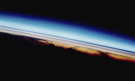
    A view from the space shuttle Atlantis of three layers of volcanic dust in the Earth’s atmosphere, following the 1991 eruption of Mount Pinatubo in the Philippines. Photograph: ISS/NASA/Corbis

    Reversing climate change via huge artificial volcanic eruptions could bring severe droughts to large regions of the tropics, according to new scientific research.

    The controversial idea of geoengineering – deliberately changing the Earth’s climate – is being seriously discussed as a last-ditch way of avoiding dangerous global warming if efforts to slash greenhouse gas emissions fail.

    But the new work shows that a leading contender – pumping sulphate particles into the stratosphere to block sunlight – could have side-effects just as serious as the effects of warming itself. Furthermore, the impacts would be different around the world, raising the prospect of conflicts between nations that might benefit and those suffering more damage.

    “There are a lot of issues regarding governance – who controls the thermostat – because the impacts of geoengineering will not be uniform everywhere,” said Dr Andrew Charlton-Perez, at the University of Reading and a member of the research team.

    The study, published in the journal Environmental Research Letters, is the first to convincingly model what happens to rainfall if sulphates were deployed on a huge scale.

    While the computer models showed that big temperature rises could be completely avoided, it also showed cuts in rain of up to one-third in South America, Asia and Africa. The consequent droughts would affect billions of people and also fragile tropical rainforests that act as a major store of carbon. “We would see changes happening so quickly that there would be little time for people to adapt,” said Charlton-Perez.

    Another member of the research team, Professor Ellie Highwood, said: “On the evidence of this research, stratospheric aerosol geoengineering is not providing world leaders with any easy answers to the problem of climate change.”

    The study considered what would happen if carbon dioxide levels quadrupled in the atmosphere – the sort of extreme situation in which geoengineering might be seriously considered. Without intervention, temperatures rose by 4C, far above the 2C level considered dangerous by the world’s governments.

    But the temperature rise was reduced to zero if a massive geoengineering effort took place. The 60m tonnes of sulphur dioxide pumped into the stratosphere each year in the simulation is equivalent to five volcanic eruptions, each on the scale of Mount Pinatubo, the huge 1991 eruption in the Philippines that cut global temperatures by about 0.5C in the following year or two.

    The sulphate particles in the model not only reflected incoming sunlight, cutting temperatures, but also absorbed heat rising up from the Earth’s surface. This reduced the temperature difference between the lower and upper atmosphere, which is the engine that drives cloud formation and rainfall. The reduction in rainfall seen in the geoengineering model was as big as the increase in rainfall projected if global warming was unabated.

    Dr Matthew Watson, a researcher at the University of Bristol and advocate of further research into geoengineering, said: “The researchers chose an extreme climate scenario so we should not be surprised if that, and any geoengineering attempt to counter it, had severe and uneven impacts.”

    He added: “It remains the case that our only guaranteed way forward is to reduce the record levels of greenhouse gases we continue to pump into the atmosphere. It’s vital that scientists continue researching geoengineering; but no government serious about climate change should should see this as a quick fix

  • We desperately need to predict what climate change is doing to UK rainfall Recent floods can’t be directly attributed to global warming but it’s still vital we refine our projections of what the future holds Share Tweet this Email The River Wye broke its banks in Byfleet in Surrey after heavy rainfall in December. The River Wye broke its banks in Byfleet in Surrey after heavy rainfall in December. Photograph: FACUNDO ARRIZABALAGA/EPA The devastation caused by intense rainfall events and associated flooding of properties over Christmas and the new year must have been dreadful for those affected. So the very last thing that needs to be heard at the moment is a set of pompous statements implying this might be due to manmade climate change. What would this achieve? Nobody wants to hear the message “it’s your fault”, and it is almost certainly not completely true anyway. At the same time, we do know that the composition of the atmosphere is changing, and predominantly with a ramping-up of carbon dioxide. The resulting warming will adjust the patterns of surface temperatures of the oceans, and change the yearly extent of sea-ice nearer the Earth’s poles. Many detailed simulations are starting to confirm that this then affects storm directions and rainfall patterns in the UK. It is correct to state, almost as a mantra, that no single period of storm events can be attributed to climate change. There always have been extreme intense rainfall occurrences and there always have been floods. What the meteorological research community is working hard to determine is the amount to which their frequency is changing. To answer this, there is continuous assessment of all available archived weather measurements. In parallel, an additional analysis is made using the best available weather forecast models, but artificially driving these computer models with different prescribed atmospheric carbon dioxide levels. What patterns then emerge from such a set of computer simulations when forced with past carbon dioxide concentrations? Do they tally with measurements? Once we see agreement for decades past, we can trust the same models far more to predict the future, corresponding to higher carbon dioxide measurements than present. Surprisingly, there is reason to believe that for some parts of the world, extreme events are starting to occur less often. There is real hope in the UK that the combination of the advanced Met Office climate models, assessed in collaboration with our research centres and key university departments, are starting to make rigorous assessments of expected change. In particular, by supplying refined estimates for how the probabilities of major storm events happening might change over the coming decades. That information will be critical for adaptation planning, including how to make our infrastructure more robust. Hence there is a pressure too on those who undertake ‘impacts calculations’ – for a given rainfall strength and duration, what are the consequences for safety, property and transport? Can we further improve estimates of soil moisture, river flow response and risk of landslides? There is a compelling argument that even should expected frequency changes be relatively small, there is still a duty to protect society as best as possible from the impacts of peaks in rainfall. With population growth and much more travel by society, inevitably larger numbers of people will be affected by extreme weather. It feels as if these days, people now just switch off when hearing any discussion of climate change and its implications. There are many reasons for this, and some are no doubt very valid. There was a period of time when even researchers working in this scientific area felt there was an over-emphasis on the concern, and to which a backlash would occur. But it is still worth remembering that even with the current “lull” in warming, averaged at the decadal timescale, the last decade has been the warmest on record. Unfortunately there is compelling evidence such warming will start to climb again and most likely will change the hydrological cycle. Hence there remains a desperate need for refinement of projections as to how rainfall patterns might evolve in to the future. It is this knowledge that will enable society to have a calm and considered discussion, allowing the UK and elsewhere to plan ahead. Such planning will need to optimise available adaptation funds, in a way to maximise safety and resilience should the weather events witnessed over recent weeks become more commonplace. • Dr Chris Huntingford is a climate modeller at the UK Centre for Ecology and Hydrology

    We d

    We desperately need to predict what climate change is doing to UK rainfall

    Recent floods can’t be directly attributed to global warming but it’s still vital we refine our projections of what the future holds

    The River Wye broke its banks in Byfleet in Surrey after heavy rainfall in December.
    The River Wye broke its banks in Byfleet in Surrey after heavy rainfall in December. Photograph: FACUNDO ARRIZABALAGA/EPA

    The devastation caused by intense rainfall events and associated flooding of properties over Christmas and the new year must have been dreadful for those affected.

    So the very last thing that needs to be heard at the moment is a set of pompous statements implying this might be due to manmade climate change. What would this achieve? Nobody wants to hear the message “it’s your fault”, and it is almost certainly not completely true anyway.

    At the same time, we do know that the composition of the atmosphere is changing, and predominantly with a ramping-up of carbon dioxide. The resulting warming will adjust the patterns of surface temperatures of the oceans, and change the yearly extent of sea-ice nearer the Earth’s poles. Many detailed simulations are starting to confirm that this then affects storm directions and rainfall patterns in the UK.

    It is correct to state, almost as a mantra, that no single period of storm events can be attributed to climate change. There always have been extreme intense rainfall occurrences and there always have been floods.

    What the meteorological research community is working hard to determine is the amount to which their frequency is changing. To answer this, there is continuous assessment of all available archived weather measurements. In parallel, an additional analysis is made using the best available weather forecast models, but artificially driving these computer models with different prescribed atmospheric carbon dioxide levels.

    What patterns then emerge from such a set of computer simulations when forced with past carbon dioxide concentrations? Do they tally with measurements? Once we see agreement for decades past, we can trust the same models far more to predict the future, corresponding to higher carbon dioxide measurements than present. Surprisingly, there is reason to believe that for some parts of the world, extreme events are starting to occur less often.

    There is real hope in the UK that the combination of the advanced Met Office climate models, assessed in collaboration with our research centres and key university departments, are starting to make rigorous assessments of expected change. In particular, by supplying refined estimates for how the probabilities of major storm events happening might change over the coming decades. That information will be critical for adaptation planning, including how to make our infrastructure more robust.

    Hence there is a pressure too on those who undertake ‘impacts calculations’ – for a given rainfall strength and duration, what are the consequences for safety, property and transport? Can we further improve estimates of soil moisture, river flow response and risk of landslides? There is a compelling argument that even should expected frequency changes be relatively small, there is still a duty to protect society as best as possible from the impacts of peaks in rainfall. With population growth and much more travel by society, inevitably larger numbers of people will be affected by extreme weather.

    It feels as if these days, people now just switch off when hearing any discussion of climate change and its implications. There are many reasons for this, and some are no doubt very valid.

    There was a period of time when even researchers working in this scientific area felt there was an over-emphasis on the concern, and to which a backlash would occur. But it is still worth remembering that even with the current “lull” in warming, averaged at the decadal timescale, the last decade has been the warmest on record.

    Unfortunately there is compelling evidence such warming will start to climb again and most likely will change the hydrological cycle. Hence there remains a desperate need for refinement of projections as to how rainfall patterns might evolve in to the future.

    It is this knowledge that will enable society to have a calm and considered discussion, allowing the UK and elsewhere to plan ahead. Such planning will need to optimise available adaptation funds, in a way to maximise safety and resilience should the weather events witnessed over recent weeks become more commonplace.

    • Dr Chris Huntingford is a climate modeller at the UK Centre for Ecology and Hydrology