 Diane and Mark Bruhn live in the Lockyer Valley and are alarmed by the mismanagement of the waterways that continues to make floods worse through landclearing. They have been trying to communicate their views to State Government about possible land management factors which may have played a part in the recent unbelievable flood they’ve had across both the 2011 and 2013 floods and now have photographic evidence supporting their case.
We tried our best in 2011, to have local and State Government listen to our concerns http://www.thechronicle.com.
 For most of the 10 years we lived in this region we have watched on in utter amazement at the way the land is treated and wondered
why? Clearly we haven’t supported some of the rather entrenched negativity towards vegetation other than grass, which has seen 75% of the Lockyer Valley catchment cleared since white settlement.
 We probably sound harsh, but the naivety show by local authorities and landholders, as to the connection between land management practices on hillslopes, creeks, riparian land and farmland, and the subsequent ‘river like’ flows of local creeks during floods, is stunning. Tons and tons of fertile soil was eroded and sent to Moreton Bay last month. This should be of huge concern to everyone living in SEQ.
Apparently this flood was 4 times dirtier than the 2011 flood. This is saying something! We have had to listen again and again to the mantra by local landholders that trees make flash flooding worse, and watched on as most of Blackfellow’s Creek and sections of Tenthill Creek had their flood damaged creek side vegetation bulldozed away, post Jan 2011. Well, I wonder what locals are saying now, they certainly cannot blame gumtrees for the flooding in Blackfellow’s Creek, there weren’t any! Anyway Mark and I have put our thoughts in this email. If you feel inclined, please send it on to whomever you think might be interested. We would like to see changes in the land management practices out here, and it probably won’t happen unless more people express their concern about the issues. Here goes!
Our thoughts have been percolating since the recent January flood, said to be the worse flood out here in 5 generationshttp://www.thechronicle.com.
Mark walked the hillslopes behind our property, the week after the flood and saw Blackfellow’s Creek winding back and forth like a large brown snake across the valley floor. He said from up in the hills the creek had all the characteristics of a river. Even though creeks can meander fairly broadly across valley floors, they are generally thought of as waterways that are kept in place by riparian vegetation, whereas rivers are generally known to define their own path, regardless of vegetation (perhaps Mark has this wrong, but it sounded like a reasonable definition of the difference between the two).
We believe, during flooding, due to the run off generated in the cleared hillslopes of the Lockyer catchment, (some hundreds of square kilometres), along with hydraulic changes (caused by the combination of the 2011 flood and heavy machinery earthworks, and stripped riparian zones), both Tenthill and Blackfellow’s Creek appear to behave more like rivers. Given these waterways are labelled ‘creeks’ and become dry fairly quickly after heavy rainfall events, this probably sounds ludicrous. But we have found ourselves questioning quite a few things since January 27, even whether these waterways retain the properties of ‘creeks! Having seen what the stream velocity in these waterways can do to standing trees, creek beds, farmland, roads, cement causeways and bridges during a flash flood (minor to medium flood level, according to BOM 27/1/13), we’ve become convinced new ways of thinking are required.
There seems historically to have been little acknowledgment by State or Local Government, as to the critical role cleared hillslope has on these creeks during heavy rainfall events (perhaps we are wrong in this, but as example, the Government funded SEQ Catchment
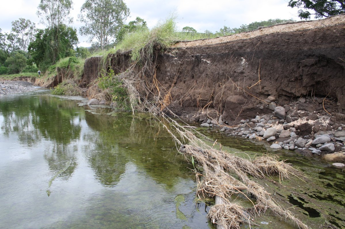
 report by Alluvium, on Blackfellow’s Creek, seems primarily focused on the restoration of the riparian area). How have the various rebuilding strategies for Mt Sylvia, Junction View and Lefthand Branch, implemented by flood recovery committees, community agencies and Local and State Government, addressed the roof of the catchment? After all, both hillslopes and creeks hold and transport water. During January 2011 flooding, water was roaring down the back of our place from the hillslopes. Boulders the size of fridges were moving with these waters. The roar we heard was from two gullies on our property (we have three separate gullies). We can only speculate as to the volume of water flowing into the creek from gullies along its full length. There is visual evidence from the scour left behind in the creek bed, after this recent flood event, of Tenthill creek flow velocity increasing exponentially as it travelled downstream.
An old timer from the top of Blackduck Creek described what he heard and saw coming down the hills in January 2011. His story is quite sad and frightening.
“Look around,” he said. “Any bit of a gully in these mountains was just sheets of white water coming off all these mountains. It just came down in white sheets. It just rained and it rained and the sheets kept coming.”
The ground shook beneath Mr Hutton’s feet as the water rolled ancient boulders the size of cars along the creek. It felt like an earthquake, he said.
“This is the second-fastest creek system in Queensland,” he said. “The speed is governed by the height of your mountains. Now these mountains here are 1000ft (304.8m) higher than Toowoomba. The fall from here to Gatton is an 800m drop.”
For years Mr Hutton, 63, has begged Queensland government environmental agencies to permit him to fell the trees that pepper the valley in front of his home, allowing a clear run off for floodwater. “When you get water coming off mountains that are 1000m high and it’s coming down, this isn’t a creek, it becomes a gutter,” he said.
He wept as he watched the torrent tear 12.9ha of land and 20 years of back-breaking solo farm maintenance from his property. With every tree it uprooted the torrent only grew stronger, thickened in density, doubled in wrecking power.
“You can’t slow it down,” he said. “It boils and it rolls trees and logs down effortlessly, gum trees so big three people can’t get their arms around them. Then you’ve got the mass weight of the water pushing as well as pulling, thousands of tonnes. And it all ended up in the Brisbane River. My soil ended up in people’s homes in Brisbane. If we could keep that creek clear and we can get that water away quick, it has less build up and depth, and you blokes wouldn’t have had all that soil in Brisbane.” http://www.couriermail.com.au/
 I don’t agree with his views on the need to remove trees or of them being the cause of flooding, but the rest paints a powerful picture of the volume of water coming down the hillslopes into the creek. This gentleman lived at the last grazing property towards the very top of Black Duck Creek. It’s not hard to imagine what might of been happening further downstream.
Our sitting member Ian Rickuss came out and saw us in 2011, he said at the time, the next few flood events would put soil back on the banks of the creek. He told us that’s how it always works, a big flood erodes the banks of the creek and smaller floods put the soil back. Hmm, didn’t happen.
 Both Mark and I totally support the development of an intact and substantial riparian zone along both creeks, but we cannot see how this can happen while the cleared hillslopes issue in the Lockyer Valley remains substantially unaddressed. We remain unconvinced that minor engineering solutions and plantings focused on restoration of riparian land, or even ceasing the cultural practice of straightening and deepening channels, will correct the problems out here. What we have now in the Lockyer Valley is a broad scale erosion problem and a very dangerous and apparently destructive creek system. In our opinion, this can only be addressed by starting at the highest point and looking for sources of run off and altering land management practices, along with creek bank and bed restoration efforts. There is irrefutable evidence that local landholders have over used all the tools of clearing, including fire, machines and grazing across all areas of the catchment in order to achieve higher levels of land productivity. Blackfellow’s creek was left with virtually no vegetation after January 2011 as a result of flood effects and heavy earth machinery works. The landholders and Local Government leaders who vocalised their strongly held beliefs about the need to clear creeks of vegetation, (particularly in channel vegetation), to protect farmland and infrastructure, and who oversaw the expenditure of extremely expensive engineering works, appear to have been just plain wrong. They seemed to ignore scientific research which suggested deeper, straighter, cleared creek channels could increase the velocity of flood waters and make things worse, especially with the volume of run off from steep cleared hillslopes (sorry to keep repeating this, but we feel the need to emphasize the point).
 In their submission to the Queensland Flood Inquiry, in 2011, Simon Warner from SEQ Catchments said, “Natural hillslopes generate little erosion, store rainfall, limit overland runoff and hence downstream flooding and sustain stream flow during dry periods. In a degraded state, where soils are exposed or compacted, or where surfaces are hardened for infrastructure development, hillslopes react quite differently. High proportions of rainfall, leave degraded hillslopes almost immediately as overland flow, which after short distances, coalesces into rills and then gullies before being transferred to streams and rivers. This runoff develops significant velocities and hence erosive forces with the result that percolation to groundwater and base flow are reduced, accelerated erosion of hillslope soils are observed and flash flooding and highly erosive overland flow occur even under moderate rainfall events. “
For interest sake I want to include part of a description of Mr Lacy’s Blackfellow’s Creek farm by a journalist from The Queenslander.
Saturday 23 September 1876, (my how things have changed)!
 “Mr. Hooper’s farm on the right and crossing the bridge, a short ride brings the visitor to Mr. Lacy’s farm. This is comprised in an area of over 600 acres of the very finest agricultural land, well watered by Blackfellow’s Creek, and containing also a fine lagoon with a never-failing supply of the purest water. From its elevated position above Blackfellow’s Creek it extends for a long distance in a perfectly level plain, where the steam plough, the mowing machine, and the horse race would meet with no obstacles or inequalities in the surface. From the house the eye roams over eighty acres of cleared land, surrounded by a belt of timber…. In the large paddock is the before-mentioned lagoon, the place of resort for countless wild ducks and other water fowl. Black swans have frequently been seen sailing majestically over it….The agricultural land appears to lie in a fertile valley between two mountain ranges clad with dense scrub. The scrub in some places comes down on either side and almost meets, and again recedes and widens out, affording space for a number of farms on the alluvial bottoms. These scrubs are alive with game : Wonga pigeons, scrub turkeys, and the ubiquitous wallaby and kangaroo swarm in its leafy covers.
 Besides this lagoon there is a most remarkable freestone gorge running for a short distance. This channel is worn out of the plain, and resembles in miniature an American cation. The sides are precipitous, and in parts the action of the water on the soft stone has worn perfectly round wells about three feet in diameter…The creek has some very fine reaches, where the stream opens out into broad lakes teeming with mullet and cod. We spread the net in the evening and caught several, fine mullet, and a cod in all respects similar to the Murray cod, so much appreciated in Victoria and New South Wales. A novel way of getting the net stretched across the lagoon was adopted: A bull mastiff was sent across with a light line round his neck. A boy at the other side received him, and by means, of the line drew the net across. There are numbers of that paradoxical animal, the Ornithorhynchus anatinus, or duck-billed platypus, in this creek. ” Full text here http://trove.nla.gov.au/ndp/
Diane and Mark Bruhn
Lefthand Branch via Mt Sylvia
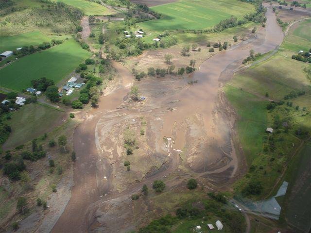
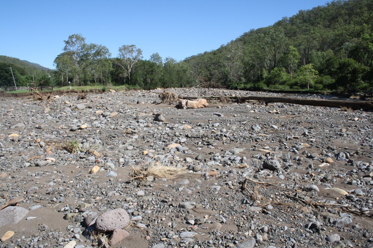
Pictures 0089 – head of Tenthill creek area taken 20ll post Jan major flood
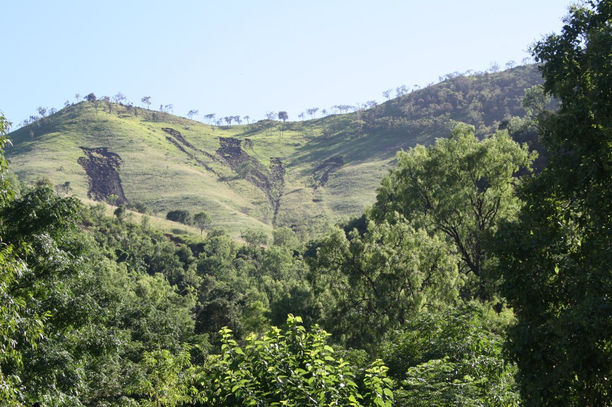
Pic 1109 hillslope above gully, showing recent slumping
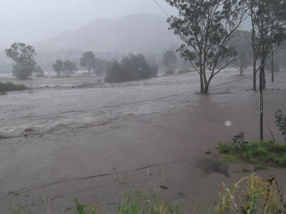
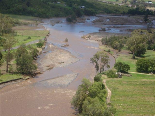
Blackfellows Creek in flood 27th Jan
Energex pics Blackfellows Creek from Jan 27 flood
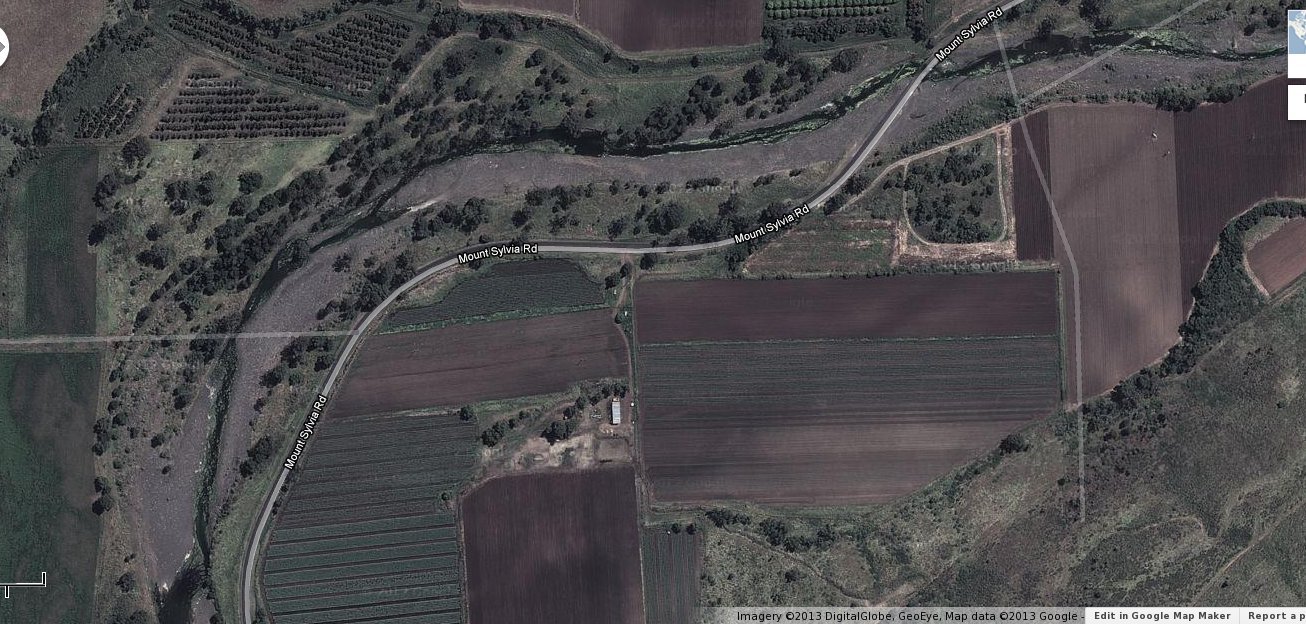
Google map 2012, showing Blackfellow’s creek, Woodbine, with very sparse riparian vegetation, post heavy earth machinery works and Jan 2011 flood
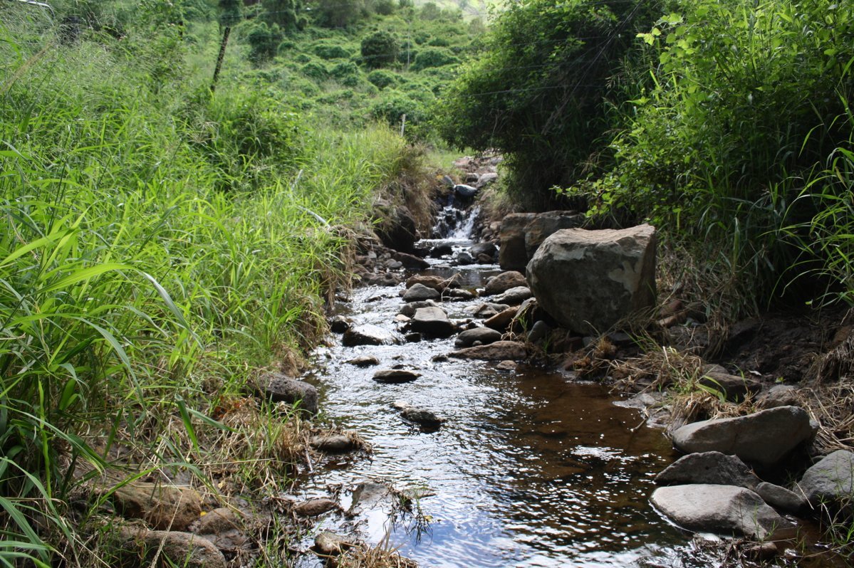
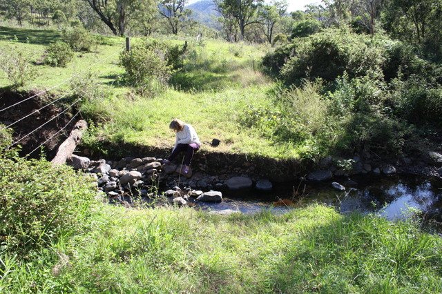
1062 Tenthill creek upstream and 1302 around our driveway a bit upstream post 27th Jan
PS I liked what I saw in this USA brochure on riparian zones and how to maintain them. http://www.bae.ncsu.edu/
This trove site described flooding infrastructure damage in 1883 in Blackfellows Creek, also Taroom, Murwillumbah and Oxley, Brisbane http://trove.nla.gov.au/ndp/
Leave a Reply
You must be logged in to post a comment.