Author: Neville

  • Ocean current

    Ocean current

    From Wikipedia, the free encyclopedia
    This article is about ocean currents. For other uses, see Current (disambiguation).
    This article needs additional citations for verification. Please help improve this article by adding citations to reliable sources. Unsourced material may be challenged and removed. (January 2014)

    The ocean currents.

    Distinctive white lines trace the flow of surface currents around the world.

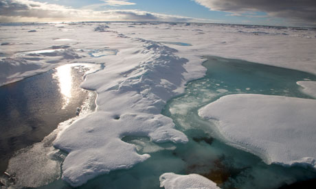
    Animation of circulation around ice shelves of Antarctica.

    An ocean current is a continuous, directed movement of seawater generated by the forces acting upon this mean flow, such as breaking waves, wind, Coriolis effect, cabbeling, temperature and salinity differences, with tides caused by the gravitational pull of the Moon and the Sun. Depth contours, shoreline configurations and interaction with other currents influence a current’s direction and strength. A deep current is any ocean current at a depth of greater than 100m.[1] A part of oceanography is the science studying ocean currents.

    Ocean currents can flow for great distances, and together they create the great flow of the global conveyor belt which plays a dominant part in determining the climate of many of the Earth’s regions. Perhaps the most striking example is the Gulf Stream, which makes northwest Europe much more temperate than any other region at the same latitude. Another example is Lima, Peru where the climate is cooler (sub-tropical) than the tropical latitudes in which the area is located, due to the effect of the Humboldt Current.

    Function

    Major ocean surface currents, (Source: NOAA)

    Device to record ocean currents

    A recording current meter

    Surface ocean currents are generally wind driven and develop their typical clockwise spirals in the northern hemisphere and counter clockwise rotation in the southern hemisphere because of the imposed wind stresses. In wind driven current, the Ekman spiral effect results in the currents flowing at an angle to the driving winds. The areas of surface ocean currents move somewhat with the seasons; this is most notable in equatorial currents.

    Ocean basins generally have a non-symmetric surface current, in that the eastern equatorward-flowing branch is broad and diffuse whereas the western poleward flowing branch is very narrow. These western boundary currents (of which the Gulf Stream is an example) are a consequence of basic fluid dynamics.

    Deep ocean currents are driven by density and temperature gradients. Thermohaline circulation, also known as the ocean’s conveyor belt which refers to the deep ocean density driven ocean basin currents. These currents, that flow under the surface of the ocean and are thus hidden from immediate detection, are called submarine rivers. These are currently being researched using a fleet of underwater robots called Argo. Upwelling and downwelling areas in the oceans are areas where significant vertical movement of ocean water is observed.

    The South Equatorial Currents of the Atlantic and Pacific straddle the equator. Though the Coriolis effect is weak near the equator (and absent at the equator), water moving in the currents on either side of the equator is deflected slightly poleward and replaced by deeper water. Thus, equatorial upwelling occurs in these westward flowing equatorial surface currents. Upwelling is an important process because this water from within and below the pycnocline is often rich in the nutrients needed by marine organisms for growth. By contrast, generally poor conditions for growth prevail in most of the open tropical ocean, because strong layering isolates deep, nutrient rich water from the sunlit ocean surface.

    Surface currents make up about 8% of all the water in the ocean. Surface currents are generally restricted to the upper 400 m (1,300 ft) of the ocean. The movement of deep water in the ocean basins is by density driven forces and gravity. The density difference is a function of different temperatures and salinity. Deep waters sink into the deep ocean basins at high latitudes where the temperatures are cold enough to cause the density to increase.

    Ocean currents are measured in sverdrup (sv), where 1 sv is equivalent to a volume flow rate of 1,000,000 m3 (35,000,000 cu ft) per second.

    Surface currents

    About 10% of the water in the world ocean is involved in surface currents, which are water flowing horizontally in the uppermost 400 meters (1,300 feet) of the ocean surface, driven mainly by wind friction. Winds drive currents that are at or near the ocean’s surface. These currents are generally measured in meters per second or in knots (1 knot = 1.85 kilometers per hour or 1.15 miles per hour).[2] surface currents move water above the pycnocline, the zone of rapid density change with depth. The primary force responsible for surface currents is wind. Most of Earth’s surface wind energy is concentrated in each hemisphere’s trade winds (easterlies) and westerlies. Waves on the sea surface transfer some of the energy from the moving air to the water by friction. This tug of wind on the ocean surface begins a mass flow of water. The water flowing beneath the wind forms a surface current. The moving water “piles up” in the direction the wind is blowing. Water pressure is higher on the “piled up” side, and the force of gravity pulls the water down the slope – against the pressure gradient- in the direction from which it came. But the Coriolis effect intervenes. Northern Hemisphere surface currents flow to the right of the wind direction, because of the Coriolis effect. Southern Hemisphere currents flow to the left. Continents and basin topography often block continuous flow and help deflect the moving water into a circular pattern. This flow around the periphery of an ocean basin is called a gyre.

    Seawater flows in six great surface circuits

    Further information: Ocean gyre

    Gyres in balance between the pressure gradient and the Coriolis effect are called geostrophic gyres, and their currents are called geostrophic currents. The geostrophic gyres are largely independent of one another in each hemisphere, because of the patterns of driving winds and the present positions of continents. There are six great current circuits in the world ocean: two in the Northern Hemisphere and four in the Southern Hemisphere. Five are geostrophic gyres: the North Atlantic gyre, the South Atlantic gyre, the North Pacific gyre, the South Pacific gyre, and the Indian Ocean gyre. Though it is a closed circuit, the sixth and largest current, known as the West Wind Drift (or Antarctic Circumpolar Current), is technically not a gyre since it does not flow around the periphery of an ocean basin. The West Wind Drift flows endlessly eastward (i.e., never deflected by a continent) around Antarctica, driven by powerful, nearly ceaseless westerly winds. While it might be assumed that the two gyres in the North and South Pacific (and the two gyres in the North and South Atlantic) converge exactly at the geographical equator, instead the junction of equatorial currents (referred to as the meteorological equator) lies a few degrees north of the geographical equator. The meteorological equator and the Intertropical Convergence Zone (the band at which the trade winds converge) are displaced 5º to 8º northward primarily because of the heat accumulated in the Northern Hemisphere’s greater tropical land surface area. Ocean circulation like atmospheric circulation, is balanced around the meteorological equator.

    Classification for geostrophic currents

    Boundary currents have different characteristics. Because of the different factors that drive and shape them, the currents that form geostrophic gyres have different characteristics. Geostrophic currents may be classified by their position within the gyre as western boundary currents, eastern boundary currents, or transverse currents.

    Type of current General features Speed Transport (millions of cubic meters per second) Special features
    Western boundary currents Warm water; narrow (< 100 km); deep (substantial transport to depths of 2 km) Swift (hundreds of kilometers per day) Large (usually 50 sv or greater) Sharp boundary with coastal circulation system; little or no coastal upwelling; waters tend to be depleted in nutrients, unproductive; waters derived from trade-wind belts
    Eastern boundary currents Cold water; broad (~ 1,000 km); shallow (< 500 m) Slow (tens of kilometers per day) Small (typically 10–15 sv) Diffuse boundaries separating from coastal currents; coastal upwelling common; waters derived from mid-latitudes
    Western boundary currents

    The western boundary currents are the fastest, deepest, and narrowest of all geostrophic currents, and they transport an extraordinary volume of water. They are found at the western boundaries of ocean basins (that is, off the east coast of continents). These currents move warm water poleward in each of the gyres. There are five large western boundary currents: the Gulf Stream (in the North Atlantic), the Japan or Kuroshio Current (in the North Pacific), the Brazil Current (in the South Atlantic), the Agulhas Current (in the Indian Ocean), and the East Australian Current (in the South Pacific). The Gulf Stream is the largest of the western boundary currents. The western boundary of the Gulf Stream is usually distinct, marked by abrupt changes in water temperature, speed, and direction. They can move for surprisingly long distances within well-defined boundaries, almost as if it were a river. However, long, straight edges are an exception, not a necessary property of western boundary currents. The western edge of these currents is often clearly visible. That is to say, the water within the current is usually warm, clear, and blue often depleted of nutrients and incapable of supporting a variety of ocean life. By contrast, water over the continental slope adjacent to the current, is often cold, green, and teeming with life. Western boundary currents meander as they flow poleward. The looping meanders sometimes connect to form turbulent rings, or eddies, that trap cold or warm water in their centers and then separate from the main flow. For example, cold-core eddies form in the Gulf Stream, meandering eastward upon leaving the coast of North America off Cape Hatteras. Warm-core eddies can form north of the Gulf Stream when the warm current loops into the cold water lying to the north. When the loops are cut off, they become freestanding spinning masses of water. Warm-core eddies rotate clockwise, whereas cold-core eddies rotate counterclockwise. The slowly rotating eddies move away from the current and are distributed across the North Atlantic. Some may be 1,000 kilometers (620 miles) in diameter and retain their identity for more than three years. In mid-latitudes, as much as one-fourth of the surface of the North Atlantic may consist of old, slow-moving, cold-core eddy remnants. Nutrients may be brought toward the surface by turbulence in eddies, which can stimulate the growth of tiny marine plantlike organisms. Recent research suggests that eddies may also influence the seafloor by slowly moving abyssal storms, which can be inferred from ripple marks that have been observed in deep sediments.

    Eastern boundary currents

    Eastern boundary currents have properties that are nearly opposite of their western boundary counterparts. Eastern boundary currents carry cold water towards the equator; they are shallow and broad, sometimes more than 1,000 kilometers (620 miles) across; their boundaries are not well defined; and eddies tend not to form. Their total flow is less than that of their western counterparts. The current is so shallow and broad that sailors may not even notice it. There are five eastern boundary currents, each of which are at the eastern edge of ocean basins (that is, off the west coast of continents): the Canary Current (in the North Atlantic), the Benguela Current (in the South Atlantic), the California Current (in the North Pacific), the West Australian Current (in the Indian Ocean), and the Peru or Humboldt Current (in the South Pacific).

    Transverse currents

    Transverse currents are currents that flow from east to west and west to east, linking the eastern and western boundary currents. They are derived from the trade winds at the fringes of the tropics and from the mid-latitude westerlies. The trade wind-driven North Equatorial Current and South Equatorial Current in the Atlantic and Pacific each transport ~30 sv westward, and are moderately shallow and broad. Since the Pacific has a greater expanse of water at the equator and stronger trade winds than the Atlantic, the Pacific develops more powerful westward flowing equatorial currents, which causes the height differential between the western and eastern Pacific to be as much as 1 meter (3.3 feet). Also, as a consequence of transverse currents, Atlantic water across the isthmus of Panama is usually 20 centimeters (8 inches) higher, on average, than water across the isthmus of Panama in the Pacific.

    Countercurrents and undercurrents

    Equatorial currents are typically accompanied by countercurrents, which flow on the surface in a direction opposite to that of the main current. At the meteorological equator, there is a continuous rising of air and a lack of presence of persistent trade winds across the boundary to drive water to the west. As a consequence, there is usually a backward (eastward) flow of water (referred to as a countercurrent) exactly at the meteorological equator, or a bit north or south of the meteorological equator. Countercurrents can sometimes be undercurrents, which are countercurrents that exist beneath the water surface. Undercurrents have been found under most major currents. The Pacific Equatorial Undercurrent, also known as the Cromwell Current, flows eastward beneath the North Equatorial Current with an average velocity of 5 kilometers (3 miles) per hour at a depth of 100–200 meters (330–660 feet). It is about 300 kilometers (190 miles) wide and carries a volume equivalent to about half the Gulf Stream. It has been traced for more than 14,000 kilometers (8,700 miles), from New Guinea to Ecuador. The first undercurrent was discovered in 1951 in the central Pacific by Townsend Cromwell, a researcher employed by the U.S. Fish and Wildlife Service.

    Wind-induced vertical circulation

    The wind-driven horizontal movement of water can sometimes induce the vertical movement of water from the deep, cold, nutrient-laden water toward the surface (a process known as upwelling). Equatorial upwelling occurs in these westward-flowing equatorial surface currents. Upwelling is an important process because water from within and below the pycnocline is often rich in the nutrients needed by marine organisms for growth. By contrast, generally poor conditions for growth prevail in most of the open tropical ocean, because strong layering isolates deep, nutrient rich water from the sunlit ocean surface. The South Equatorial Currents of the Atlantic and Pacific straddle the geographic equator. Though the Coriolis effect is weak near the equator (and absent at the equator), water moving in the currents on either side of the equator is deflected slightly poleward. Water north of the equator veers to the right (northward), and water to the south veers to the left (southward). Surface water therefore diverges, allowing deep water to replace surface water. Most of the upwelled water comes from the area above the equatorial undercurrent, at depths of 100 meters or less.

    Langmuir circulation

    Winds that blow steadily across the ocean, and the small waves that such winds generate, can induce long sets of counter-rotating vortices (or cells) in the surface water, referred to as Langmuir circulation. These slowly twisting vortices align in the direction of the wind. It usually takes about an hour for a particle in a vortex to complete one revolution. Streaks of foam (or seaweed or debris), called windrows, collect in areas where adjacent vortices converge, while regions of divergence remain relatively clear. Langmuir circulation rarely disturbs the ocean below a depth of about 20 meters (66 feet). Langmuir circulation occurs within the surface layer, which is above the pycnocline, and thus does not cause upwelling.

    Thermohaline circulation

    Coupling data collected by NASA/JPL by several different satellite-borne sensors, researchers have been able to “break through” the ocean’s surface to detect “Meddies” — super-salty warm-water eddies that originate in the Mediterranean Sea and then sink more than a half-mile underwater in the Atlantic Ocean. The Meddies are shown in red in this scientific figure.

    Horizontal and vertical currents also exist below the pycnocline in the ocean’s deeper waters. The movement of water due to differences in density as a function of water temperature and salinity is called thermohaline circulation. The whole ocean is involved in slow thermohaline circulation. Ripple marks in sediments, scour lines, and the erosion of rocky outcrops on deep-ocean floors are evidence that relatively strong, localized bottom currents exist. Some of these currents may move as rapidly as 60 centimeters (24 inches) per second.

    These currents are strongly influenced by bottom topography, since dense, bottom water must forcefully flow around seafloor projections. Thus, they are sometimes called contour currents. Bottom currents generally move equator-ward at or near the western boundaries of ocean basins (below the western boundary surface currents). The deep-water masses are not capable of moving water at speeds comparable to that of wind-driven surface currents. Water in some of these currents may move only 1 to 2 meters per day. Even at that slow speed, the Coriolis effect modifies their pattern of flow.

    Downwelling of deep water in polar regions

    Antarctic Bottom Water is the most distinctive of the deep-water masses. It is characterized by a salinity of 34.65‰, a temperature of -0.5°C (30°F), and a density of 1.0279 grams per cubic centimeter. This water is noted for its extreme density (the densest in the world ocean), for the great amount of it produced near Antarctic coasts, and for its ability to migrate north along the seafloor. Most Antarctic Bottom Water forms near the Antarctic coast south of South America during winter. Salt is concentrated in pockets between crystals of pure water and then squeezed out of the freezing mass to form a frigid brine. Between 20 million and 50 million cubic meters of this brine form every second. The water’s great density causes it to sink toward the continental shelf, where it mixes with nearly equal parts of water from the southern Antarctic Circumpolar Current. The mixture settles along the edge of Antarctica’s continental shelf, descends along the slope, and spreads along the deep-sea bed, creeping north in slow sheets. Antarctic Bottom Water flows many times as slowly as the water in surface currents: in the Pacific it may take a thousand years to reach the equator. Antarctic Bottom Water also flows into the Atlantic Ocean basin, where it flows north at a faster rate than in the Pacific. Antarctic Bottom Water has been identified as high as 40º N on the Atlantic floor.

    A small amount of dense bottom water also forms in the northern polar ocean. Although, the topography of the Arctic Ocean basin prevents most of the bottom water from escaping, with the exception of deep channels formed in the submarine ridges between Scotland, Iceland, and Greenland. These channels allow the cold, dense water formed in the Arctic to flow into the North Atlantic to form North Atlantic Deep Water. North Atlantic Deep Water forms when the relatively warm and salty North Atlantic Ocean cools as cold winds from northern Canada sweep over it. Exposed to the chilled air, water at the latitude of Iceland releases heat, cools from 10°C to 2°C, and sinks. Gulf Stream water that sinks in the north is replaced by warm water flowing clockwise along the U.S. east coast in the North Atlantic gyre.

    Importance

    A 1943 map of the world’s ocean currents.

    Knowledge of surface ocean currents is essential in reducing costs of shipping, since traveling with them reduces fuel costs. In the sail-ship era knowledge was even more essential. A good example of this is the Agulhas Current, which long prevented Portuguese sailors from reaching India. Even today, the round-the-world sailing competitors employ surface currents to their benefit. Ocean currents are also very important in the dispersal of many life forms. An example is the life-cycle of the European Eel.

    Ocean currents are important in the study of marine debris, and vice versa. These currents also affect temperatures throughout the world. For example, the current that brings warm water up the north Atlantic to northwest Europe stops ice from forming by the shores, which would block ships from entering and exiting ports, the currents have a decisive role in influencing the climate of the regions they flow through. The cold currents that flow from the polar and sub-polar regions, bring in a lot of plankton. Since this is the food of the fish you can find a lot of fish where these currents pass through.

    OSCAR: Near-realtime global ocean surface current data set

    The ‘OSCAR near-realtime global ocean circulation data set’ is based on NOAA and NASA satellite data (sea level altimetry, surface vector winds, and SST). The data set extends from 1993–present and is available at 1-degree and 1/3-degree resolution. The OSCAR data are continuously updated on an interactive website from which users can create customized graphics and download the data. A section of the website provides validation studies in the form of graphics comparing OSCAR data with moored buoys and global drifters.

    OSCAR data are used extensively in climate studies. Monthly maps and anomalies have been published in the monthly Climate Diagnostic Bulletin since 2001, and are used routinely to monitor ENSO and to test prediction models. OSCAR currents are routinely used to evaluate the surface currents in Global Circulation Models (GCMs), for example in NCEP Global Ocean Data Assimilation System (GODAS) and European Centre for Medium-Range Weather Forecasts (ECMWF).[3]

    See also

    References

    1. Essentials of Geology, 3rd ed., Stephen Marshak
    2. “noaa ocean current service education”. Retrieved 12/5/2013.
    3. OSCAR website

    E

  • Global Sea Level Rise Map

    Home  »  Climate Chaos   »   Global Sea Level Rise Map

    Global Sea Level Rise Map

    Posted in Climate Chaos By admin On March 15, 2012


    geology

    C

    The map below can be used to show which areas would be under water if sea level rises a specific amount. You can select a value of sea level rise using the drop down box in the upper left corner of the map. Although this map is not a carefully surveyed and extremely accurate presentation, it does provide a visually striking view of what geographic areas might be flooded if global climate change continues unabated.

    Note: Some inland depressions, such as the Caspian Sea, show inundation on the map but would not be flooded. This is because the mapping algorithm is based upon elevation and can not distinguish areas that are separated from the oceans by a ridge or other high area. Be sure that you trace a connection with the ocean before assuming the area would be flooded.

    This sea level rise map was created by Alex Tingle of firetree.net using the Google Maps API, NASA data and lots of programming savvy. He explains how the map was created, the sea level data and issues about map accuracy here. We thank Alex for allowing us to share this map on Geology.com. Also thanks to Google and NASA for providing the resources needed to make this map.


    © 2005-2012 Geology.com. All Rights Reserved.
    Images, code and content of this website are property of Geology.com. Use without permission is prohibited. Pages on this site are protected by Copyscape.
  • Sea level rise maps Australia

    Sea level rise maps

    With around 85% of Australia’s population living in the coastal zone, rising sea levels and storm surges will have significant impacts on many of our coastal towns and cities.

    Understanding the risks to infrastructure and private property is particularly important for highly populated urban areas.

    The Australian Government has developed a series of initial sea level rise maps to illustrate the potential impacts of climate change for key urban areas. You can access the maps by selecting a region in the box on the right, or by clicking on the map below.

    The maps have been prepared by combining a sea level rise value with a high tide value. They illustrate an event that could be expected to occur at least once a year, but possibly more frequently, around the year 2100.

    Maps are available to show three sea level rise scenarios: low sea level rise (0.5m), medium sea level rise (0.8m) and high sea level rise (1.1m). These sea level rise scenarios are for a 2100 period, relative to 1990. The sea level rise values are based on IPCC projections (B1 and A1FI scenarios) and more recent science (see information on the right).

    The low scenario represents sea level rise that is likely to be unavoidable. The medium scenario is in line with recent global emissions and observations of sea level rise. The high end scenario considers the possible high-end risk identified in 4th Assessment Report (AR4) and includes new evidence on icesheet dynamics published since 2006 and after AR4. The sea level rise values were based on Intergovernmental Panel on Climate Change (IPCC) projections and more recent science and observations.

    The maps are based on a simple modelling approach and should be considered as approximate only. The actual impacts may vary as this model does not take account of existing sea walls, storm surge, erosion or other local factors, and it does not include consideration of any future protective action that may be taken.

    Click on a region to access inundation images

    Figure 1. Urban areas where sea level rise maps are available

    Go to frequently asked questions

    If you have questions about coastal climate change please contact:

    Department of Climate Change and Energy Efficiency
    General enquiries

    Phone: 1800 057 590 within Australia
    Email: enquiries@climatechange.gov.au
    Monday to Friday 9:00 am – 6:00 pm AEDST
    Media enquiries

  • Sea levels continue to rise, but not uniformly: CSIRO

    Australia
    The Conversation

    • Academic rigour, journalistic flair
    22 July 2011, 4.42pm AEST

    Sea levels continue to rise, but not uniformly: CSIRO

    Global average sea levels continue to rise but readings vary greatly depending on when and where they are taken, a leading…

    The rate at which sea levels are rising can change depending on when or where the measurements were taken, scientists say. Flickr/Brentbat

    Global average sea levels continue to rise but readings vary greatly depending on when and where they are taken, a leading expert on coastal impacts of climate change has said, warning that selective sea level readings do not give an accurate overall picture.

    CSIRO observations show the global sea level rise since 1993 has been between 2.8-3.2 mm per year, near the upper end of predictions made by the Intergovernmental Panel on Climate Change (IPCC), said a CSIRO expert on coastal climate change, Dr Kathy McInnes.

    “But there is a huge amount of variability in the rate of rise,” said Dr McInnes, a contributing author to the IPCC second, third and fourth assessment reports and a lead author on an IPCC Special Report on Extremes.

    “If you go back to around the 1930s and 40s you get a declining trend. If you go back earlier than that, you see acceleration. If you look at records later than that, you see acceleration.”

    Dr McInnes’ comments follow recent media reports that sea level rises are decelerating, which referred to research by the principal coastal specialist at the NSW Department of Environment, Climate Change and Water, Phil Watson.

    Mr Watson’s findings were based on readings of long tide gauge records taken at Fremantle, Auckland, Fort Denison and Newcastle and found a “consistent trend of weak deceleration at each of these gauge sites throughout Australasia over the period from 1940 to 2000.”

    However, Mr Watson said the media report had misrepresented his findings.

    “Unfortunately the Australian article, Sea-level rises slowing: tidal records, misrepresented my research work by saying that “global warming is not affecting sea levels”,” he said, adding that his department had sent a letter to the editor about the report.

    “My research analysed trends in historical regional sea level data but did not draw conclusions about the impacts of global warming on sea level rise,” he said.

    A longer term data set was needed to get an accurate picture about sea level rises, said Dr McInnes.

    “One of the points [Watson] makes in the paper is that because of natural climate variability, which influences the sea level record, it may take 10 – 20 more years of records to determine more conclusively the role of global warming on recent sea level trends,” Dr McInnes said.

    Sea levels around the Australian coast rose an average of 5 – 6mm per year between 1993 and early 2011, CSIRO observations show, well above the 20th Century average of 1.7 mm per year.

  • Seven facts you need to know about the Arctic methane

    Seven facts you need to know about the Arctic methane timebomb

    Dismissals of catastrophic methane danger ignore robust science in favour of outdated mythology of climate safety
    Melting ice in the Arctic.

    Melting ice in the Arctic. Photograph: Getty

    Debate over the plausibility of a catastrophic release of methane in coming decades due to thawing Arctic permafrost has escalated after a new Nature paper warned that exactly this scenario could trigger costs equivalent to the annual GDP of the global economy.

    Scientists of different persuasions remain fundamentally divided over whether such a scenario is even plausible. Carolyn Rupple of the US Geological Survey (USGS) Gas Hydrates Project told NBC News the scenario is “nearly impossible.” Ed Dlugokencky, a research scientist at the National Oceanic and Atmospheric Administration’s (NOAA) said there has been “no detectable change in Arctic methane emissions over the past two decades.” NASA’s Gavin Schmidt said that ice core records from previously warm Arctic periods show no indication of such a scenario having ever occurred. Methane hydrate expert Prof David Archer reiterated that “the mechanisms for release operate on time scales of centuries and longer.” These arguments were finally distilled in a lengthy, seemingly compelling essay posted on Skeptical Science last Thursday, concluding with utter finality:

    “There is no evidence that methane will run out of control and initiate any sudden, catastrophic effects.”

    But none of the scientists rejecting the plausibility of the scenario are experts in the Arctic, specifically the East Siberia Arctic Shelf (ESAS). In contrast, an emerging consensus among ESAS specialists based on continuing fieldwork is highlighting a real danger of unprecedented quantities of methane venting due to thawing permafrost.

    So who’s right? What are these Arctic specialists saying? Are their claims of a potentially catastrophic methane release plausible at all? I took a dive into the scientific literature to find out.

    What I discovered was that Skeptical Science’s unusually skewered analysis was extremely selective, and focused almost exclusively on the narrow arguments of scientists out of touch with cutting edge developments in the Arctic. Here’s what you need to know.

    1. The 50 Gigatonne decadal methane pulse scenario was posited by four Arctic specialists, and is considered plausible by Met Office scientists

    The authors of the controversial new Nature paper on costs of Arctic warming didn’t just pull their decadal methane catastrophe scenario out of thin air. The scenario was first postulated in 2008 by Dr Natalie Shakhova of the University of Alaska Fairbanks, Dr Igor Semiletov from the Pacific Oceanological Institute at the Russian Academy of Sciences, and two other Russian experts.

    Their paper noted that while seabed permafrost underlaying most of the ESAS was previously believed to act as an “impermeable lid preventing methane escape,” new data showing “extreme methane supersaturation of surface water, implying high sea-to-air fluxes” challenged this assumption. Data showed:

    “Extremely high concentrations of methane (up to 8 ppm) in the atmospheric layer above the sea surface along with anomalously high concentrations of dissolved methane in the water column (up to 560 nM, or 12000% of super saturation).”

    One source of these emissions “may be highly potential and extremely mobile shallow methane hydrates, whose stability zone is seabed permafrost-related and could be disturbed upon permafrost development, degradation, and thawing.” Even if the methane hydrates are deep, fissures, taliks and other soft spots create heat pathways from the seabed which warms quickly due to shallow depths. Various mechanisms for such processes have been elaborated in detail.

    The paper then posits the plausibility of a 50 Gigatonne (Gt) methane release occurring abruptly “at any time.” Noting that the total quantity of carbon in the ESAS is “not less than 1,400 Gt”, the authors wrote:

    “Since the area of geological disjunctives (fault zones, tectonically and seismically active areas) within the Siberian Arctic shelf composes not less than 1-2% of the total area and area of open taliks (area of melt through permafrost), acting as a pathway for methane escape within the Siberian Arctic shelf reaches up to 5-10% of the total area, we consider release of up to 50 Gt of predicted amount of hydrate storage as highly possible for abrupt release at any time. That may cause ∼12-times increase of modern atmospheric methane burden with consequent catastrophic greenhouse warming.”

    So the 50 Gt scenario used by the new Nature paper does not postulate the total release of the ESAS methane hydrate reservoir, but only a tiny fraction of it.

    The scale of this scenario is roughly corroborated elsewhere. A 2010 scientific analysis led by the UK’s Met Office in Review of Geophysics recognised the plausibility of catastrophic carbon releases from Arctic permafrost thawing of between 50-100 Gt this century, with a 40 Gt carbon release from the Siberian Yedoma region possible over four decades.

    Shakhova and her team have developed these findings from data derived from over 20 field expeditions from 1999 to 2011. In 2010, Shakhova et. al published a paper in Science based on their annual research trips which highlighted that the ESAS was a key reservoir of methane “more than three times as large as the nearby Siberian wetland… considered the primary Northern Hemisphere source of atmospheric methane.” Current average methane concentrations in the Arctic are:

    “about 1.85 parts per million, the highest in 400,000 years” and “on par with previous estimates of methane venting from the entire World Ocean.”

    As the ESAS is shallow at only 50 metres, most of the methane being released is escaping into the atmosphere rather than being absorbed into water.

    The existence of such shallow methane hydrates in permafrost – at depths as small as 20m – was confirmed by Shakhova in the Journal of Geophysical Research. There has been direct observation and sampling of these hydrates by Russian geologists in recent decades until now; this has also been confirmed by US government scientists.

    2. Arctic methane hydrates are becoming increasingly unstable in the context of anthropogenic climate change and it’s impact on diminishing sea ice

    The instability of Arctic methane hydrates in relation to sea ice retreat – not predicted by conventional models – has been increasingly recognised by experts. In 2007, a study in Eos, Transactions found that:

    “Large volumes of methane in gas hydrate form can be stored within or below the subsea permafrost, and the stability of this gas hydrate zone is sustained by the existence of permafrost. Degradation of subsea permafrost and the consequent destabilization of gas hydrates could significantly if not dramatically increase the flux of methane, a potent greenhouse gas, to the atmosphere.”

    In 2009, a research team of 19 scientists wrote a paper in Geophysical Research Letters documenting how the past thirty years of a warming Arctic current due to contemporary climate change was triggering unprecedented emissions of methane from gas hydrate in submarine sediments beneath the seabed in the West Spitsbergen continental margin. Prior to the new warming, these methane hydrates had been stable at water depths as shallow as 360m. Over 250 plumes of methane gas bubbles were found rising from the seabed due to the 1C temperature increase in the current:

    “… causing the liberation of methane from decomposing hydrate… If this process becomes widespread along Arctic continental margins, tens of Teragrams of methane per year could be released into the ocean.”

    The Russian scientists investigating the ESAS also confirmed that the levels of methane release they discovered were new. As Steve Connor reported in the Independent, since 1994 Igor Semilitov:

    “… has led about 10 expeditions in the Laptev Sea but during the 1990s he did not detect any elevated levels of methane. However, since 2003 he reported a rising number of methane ‘hotspots’, which have now been confirmed using more sensitive instruments.”

    In 2012, a Nature study mapping over 150,000 Arctic methane seeps concluded that:

    “… in a warming climate, disintegration of permafrost, glaciers and parts of the polar ice sheets could facilitate the transient expulsion of 14C-depleted methane trapped by the cryosphere cap.”

    3. Multiple scientific reviews, including one by over 20 Arctic specialists, confirm decadal catastrophic Arctic methane release is plausible

    A widely cited 2011 Nature review dismissed such a catastrophic scenario as implausible because methane “gas hydrates occur at low saturations and in sediments at such great depths below the seafloor or onshore permafrost that they will barely be affected by [contemporary levels of] warming over even [1,000] yr.”

    But this study and others like it completely ignore the new empirical evidence on permafrost-associated shallow water methane hydrates on the Arctic shelf. Scientific reviews that have accounted for the empirically-observed dynamics of permafrost-associated methane come to the opposite conclusion.

    In 2007, scientists Matthew Reagan and George Moridis at the Lawrence Berkeley National Laboratory published a paper in Geophysical Research Letters exploring the vulnerability of methane gas hydrates. They concluded based on simulations of different types of oceanic gas hydrate responding to seafloor temperature changes:

    “… while many deep hydrate deposits are indeed stable under the influence of rapid seafloor temperature variations, shallow deposits, such as those found in arctic regions or in the Gulf of Mexico, can undergo rapid dissociation and produce significant carbon fluxes over a period of decades.”

    A 2010 scientific analysis led by the UK’s Met Office in Review of Geophysics found:

    “The time scales for destabilization of marine hydrates are not well understood and are likely to be very long for hydrates found in deep sediments but much shorter for hydrates below shallow waters, such as in the Arctic Ocean… Overall, uncertainties are large, and it is difficult to be conclusive about the time scales and magnitudes of methane feedbacks, but significant increases in methane emissions are likely, and catastrophic emissions cannot be ruled outThe risk of a rapid increase in [methane] emissions is real but remains largely unquantified.”

    Another extensive scientific review of data from the ESAS gathered between 1995 and 2011 by over twenty Arctic specialists published in the Proceedings of the Russian Academy of Sciences similarly concluded that:

    “The [ESAS] is a powerful supplier of methane to the atmosphere owing to the continued degradation of the submarine permafrost, which causes the destruction of gas hydrates. The emission of methane in several areas of the [ESAS] is massive to the extent that growth in the methane concentrations in the atmosphere to values capable of causing a considerable and even catastrophic warning on the Earth is possible.”

    Other recent scientific reviews corroborate these findings.

    4. Current Arctic methane levels are unprecedented

    A 2011 Nature paper found that ten times more carbon than thought is escaping via thawing coastal permafrost at the ESAS. Although it is not yet clear whether or how the quantities of Arctic methane are impacting on total atmospheric methane emissions, a number of scientists argue that the increasing spikes in methane detected in the Arctic in recent years is indeed unprecedented.

    Despite NOAA scientist Dr Dlugokencky‘s reassurances that current Arctic methane emission levels are nothing to be “alarmed” about, his own data shows that Arctic methane levels were 1850 ppb in yr 2000, rising up to 1890 ppb in 2012.

    Indeed, Dr Leonid Yurganov, Senior Research Scientist at the NASA/UMBC Joint Centre for Earth Systems Technology, and his co-scientists from NOAA and Harvard (Shawn Xiong and Steven Wofsy) disagree with Dlugokencky. In a paper for the American Geophysical Union last December they charted a worrying “global increase of methane” since 2007-8, with particular spikes in 2009 and 2011-12 in the northern hemisphere, with maximum methane concentrations in the Arctic:

    “IASI data for the autumn months (October-November) clearly indicate Eurasian shelf areas of the Arctic Ocean as a significant methane emitter. The maximal methane concentrations were found over Kara and Laptev Seas. According to IASI data, during the last three years in autumn time, methane over Eurasian shelf has been increased by 25 ppb, over the N. American shelf, by 23 ppb, and over the land between 50 N and 70 N for both Eastern and Western hemispheres, by 20 ppb.”

    Yurganov et. al point out that between January 2009 and 2013, Arctic methane levels ramped steadily higher by about 10-20 ppb on average each year. They also note that maximum Arctic methane emissions occur annually between September and October – coinciding with the Arctic sea ice minimum.

    5. The tipping point for continuous Siberian permafrost thaw could be as low as 1.5C

    New research led by Prof Antony Vaks published this year in Science analysing a 500,000 year history of Siberian permafrost found that “global climates only slightly warmer than today are sufficient to thaw significant regions of permafrost.” The study by eight experts found that there is a tipping point for continuous thawing of permafrost at 1.5C which “can potentially lead to substantial release of carbon trapped in the permafrost into the atmosphere.”

    6. Arctic conditions during the Eemian interglacial lasting from 130,000 to 115,000 years ago are a terrible analogy for today’s Arctic

    Two recent studies challenge the relevance of Arctic conditions in the Eemian interglacial. A 2012 Geophysical Research Letters study rejects the idea that the Arctic experienced ice free summers in the Eemian, noting that Arctic temperatures were cooler than previously thought, with evidence that ice sheets were more resistant – partly due to vastly different Arctic ocean currents. Similarly, a new Nature study found that the Greenland ice sheets experienced only modest melting in the Eemian, such that the extensive sea level rise at the time could only be explained by melting in Antarctica. Both studies suggest that the Arctic sea ice simply had not retreated enough to expose permafrost.

    According to Prof Paul Beckwith of the University of Ottawa Laboratory for Paleoclimatology and Climatology, this can be explained by a number of factors:

    “… the key distinction is that the warming today is from Greenhouse gases being higher and occurs ‘twenty-four seven’, namely the cooling at night is much less (diurnal variation smaller); in the Eemian the tilt of the Earth was much greater so there was much more seasonality, thus winters were much colder so the sea ice extent, thickness, and thus volume could build up much more, and the summers were warmer in the daytime, however the cooling at night was much greater than now (less greenhouse gas [GHG], more diurnal variation); net result is that the ice was much more durable in the Eemian. Greenland temps were higher during the daytime, but cooled off much more during the nighttime in the lower GHG concentration world.”

    7. Paleoclimate records will not necessarily capture a large, abrupt methane pulse

    Prof Beckwith also poured (ice cold) water on the claim that we know an abrupt methane release cannot occur, because it has never occurred before – purportedly proven as such an event is not detected in the ice cores:

    “The length of time for the methane pulse is very important here. If most of the methane came out in a decade, for example then within a subsequent decade or so most of the methane will have been broken down to CO2 and H20 and also been dispersed/distributed around the planet, away from the pulse source area in the Arctic. The CO2 produced would have been small (CO2 stayed within 180-280 ppm range). It takes about 50 years or even more (depending on the snowfall rate and surface melt rates) for snow at the surface to be compacted into firn that closes off the air spaces creating the bubbles in the ice that are reservoirs of the methane and other atmospheric gases. Because of that 50 year bubble closure time, the large pulse of methane that was burped out of the marine sediments and terrestrial permafrost would be long gone and not result in a detectable signal in the ice core record. Just because the record does not capture it does not mean that it was not produced.”

    These comments are confirmed by an in-depth American Geophysical Union study which notes that it “remains unclear if the full magnitude of atmospheric [methane] changes are recorded in ice cores because of diffusional smoothing of the [methane] while in the firn” as well as “signal smoothing” caused by “atmospheric effects.”

    But studies do indicate past precedent. A 2009 Science paper argues that abrupt, catastrophic emissions from Arctic methane clathrates including from thawing permafrost played a key role 11,600 years ago at the end of the Younger Dryas cold period in driving wetland emissions, generating sudden massive warming.

    So what?

    All this proves that the $60 trillion price-tag for Arctic warming estimated by the latest Nature commentary should be taken seriously, prompting further urgent research and action on mitigation – rather than denounced on the basis of outdated, ostrich-like objections based on literature unacquainted with the ESAS.

    Dr Nafeez Ahmed is executive director of the Institute for Policy Research & Development and author of A User’s Guide to the Crisis of Civilisation: And How to Save It among other books. Follow him on Twitter @nafeezahmed

  • Thorium: Energy Savior or Red Herring?

    Subscribe Now

    Receive our latest investment report & stategy update this Friday

    • Investing advice from veteran oil traders & analysts
    • Discover trends & opportunities ahead of other investors
    • Strategic advice from corporate & military intelligence analysts
    • It’s 100% FREE & you can cancel anytime

    Hide

    Thorium: Energy Savior or Red Herring?

    By Andrew Topf | Wed, 18 June 2014 22:03 | 8

    Benefit From the Latest Energy Trends and Investment Opportunities before the mainstream media and investing public are aware they even exist. The Free Oilprice.com Energy Intelligence Report gives you this and much more. Click here to find out more.

    Have you ever heard of Admiral Rickover? Fans of “The Hunt for Red October,” the 1990 thriller starring Sean Connery as a rogue Russian submarine captain, may know that Rickover is the U.S. admiral responsible for creating the world’s first nuclear-powered sub.

    Considered “The Father of the Nuclear Navy,” Hyman G. Rickover moved up the ranks during the World War II, and then afterwards was tasked with developing a system of naval nuclear propulsion while working for the Atomic Energy Commission – an agency whose role, ironically, was to work out how atomic energy could be used for civilian purposes rather than military ones.

    Select the reports you are interested in:

    NO-SPAM: Under no circumstances will we EVER rent, sell or give away your email

    After the war, the United States was experimenting with different fuels for generating a nuclear reaction, and the leading contenders were uranium — the metallic element “U” on the periodic table of the elements — and thorium — represented on the table as the symbol “Th.” Uranium’s chief advantage over thorium was that it could be used to produce both atomic weapons and nuclear power, while thorium, unlike uranium, is not “fissile” – meaning it cannot be split to make a nuclear chain reaction – and could only be applied to nuclear power.

    With the United States in the early stages of an arms race against the former Soviet Union to develop a nuclear arsenal, it was easy to see which element would win out. While thorium was used in a later version of America’s first civilian nuclear power plant — also headed up by Admiral Rickover — it would take a back seat to uranium as the primary fuel for nuclear reactors.

    Less Radioactive Waste

    Related Article: China National Nuclear Power Co. Plans $2.6B IPO

    Recently, thorium has generated a fair amount of excitement for its potential as so-called “green nuclear” power, especially in the wake of the Fukushima Daiichi nuclear plant meltdown that occurred after the 2011 Japanese tsunami. Fukushima may have soured the world on nuclear, with many people calling it too dangerous and calling for its end, but nuclear power plants remain a cheap, reliable and relatively clean source of electricity compared to their fossil-fuel cousins, coal and natural gas.

    What’s green about thorium? First, thorium reactors are more efficient than uranium reactors, because they waste less fuel and produce far more energy. Most nuclear power plants are currently only able to extract between 3 and 5 percent of the energy in uranium fuel rods. In molten salt-cooled reactors, favored by many thorium proponents, nearly all the fuel is consumed. According to a pro-thorium group of British lawmakers, one metric tonne of thorium delivers the same amount of energy as 250 tonnes of uranium.

    Second, and perhaps most important from a “green” perspective, thorium yields little waste and is less radioactive. According to its proponents, residue from the thorium reaction will become inert within 30 years, compared to 10,000 years for radioactive waste currently generated from uranium reactors.

    A further advantage thorium has over uranium is its relative abundance in the Earth’s crust. The silvery-black metal is estimated to be three to four times more plentiful than uranium, with large reserves existing in China, Australia, the United States, Turkey, India and Norway. Tons of it are known to be buried in the U.S., since thorium is a by-product of rare earth mining.

    China Aims For First

    So, if thorium is such a wonder-metal, why hasn’t it been accelerated? (Pardon the pun.) There is currently a race on to develop a functioning thorium reactor, with the number one and two positions held by China and Norway. Last year, Thor Energy, a private Norwegian company, started producing power from thorium at its Halden test reactor, with help from nuclear giant Westinghouse. Uranium-poor India and France are among other countries developing thorium research programs.

    All of them, however, will be chasing China, which according to a recent Telegraph article, is “going for broke” to build the first thorium reactor within the next 10 years. The project reportedly started with a budget of $350 million and the recruitment of 140 scientists at the Shanghai Institute of Nuclear and Applied Physics. It plans to have 750 employees by 2015.

    So should the nuclear industry herald the death of uranium and make way for this new thorium darling? Not so fast, skeptics say.

    Long Road Ahead

    Related Article: Nigeria Planning Country’s First Nuclear Power Plant

    One large hole that can be punched in the argument for thorium involves the economics of thorium reactors. Experts say compared to uranium, the thorium fuel cycle is more costly and would require extensive taxpayer subsidies.

    Another issue is time. With a viable thorium reactor at least a decade away if not more, the cost of renewable alternatives like solar and wind may come down to a point where thorium reactors won’t be economical. Critics also point out that the nuclear industry has invested too much in uranium reactors – along with government buy-in and a set of regulations around them – to be supplanted by thorium.

    As for the “green nuclear” argument, thorium’s detractors say that isn’t necessarily the case. While thorium reactors produce less waste, they also produce other radioactive by-products that will need safe disposal, including U-232, which has a half-life of 160,000 years.

    “It will create a whole new volume of radioactive waste from previously radio-inert thorium, on top of the waste from uranium reactors. Looked at in these terms, it’s a way of multiplying the volume of radioactive waste humanity can create several times over,” said Oliver Tickell, author of Kyoto2, speaking to The Guardian.

    Will thorium be a fool’s errand or the fuel that heralds the dawn of a new age of nuclear power? It is certainly too early to say, but one thing is for sure: thorium has great potential and with the right backers, could become a viable adjunct to uranium, if not a serious competitor.

    By Andrew Topf Oilprice.com