Author: Neville

  • Arctic sea ice shrinks to sixth-lowest extent on record

    Arctic sea ice shrinks to sixth-lowest extent on record

    Sea ice recovers from record low of 2012 but long-term trend continues towards an ice-free Arctic during the summer months

    Eco audit live blog: how fast is Arctic sea ice melting?

    Melting sea ice near Ellesmere Island.

    Melting sea ice near Ellesmere Island, Canada. Photograph: Gordon Wiltsie/ Gordon Wiltsie/National Geogra
    Arctic sea ice extent September 2013.  Photograph: guardian.co.uk 
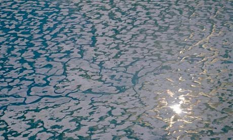
Arctic sea ice extent September 2013. Photograph: guardian.co.ukSea ice cover in the Arctic has shrunk to one of its smallest extents on record, bringing the days of an entirely ice-free Arctic during the summer a step closer.

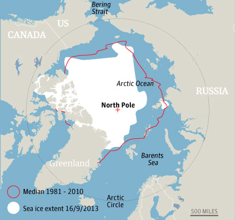
    The annual sea ice minimum of 5,099m sq km reached last Friday was not as extreme as last year, when the collapse of ice cover broke all previous records.

    But it was still the sixth lowest Arctic sea ice minimum on record, and well below the average set over the past 30 years of satellite records.

    This suggests the Arctic will be entirely ice-free in the summer months within decades, scientists said.

    The annual sea ice minimum, based on a five-day average, is expected to be officially declared by the US National Snow and Ice Data Centre in Boulder, Colorado, within the next few days.

    “It certainly is continuing the long-term decline,” said Julienne Stroeve, a scientist at the centre. “We are looking at long-term changes and there are going to be bumps and wiggles along the long-term declining trend, but all the climate models are showing that we are eventually going to lose all of that summer sea ice.”

    Overall, the Arctic has lost about 40% of its sea ice cover since 1980. Most scientists believe the ocean at the north pole could be entirely ice-free in the summer by the middle of the century – if not sooner.

    Arctic sea ice extent graph 
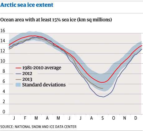
Arctic sea ice extent graph. Photograph: guardian.co.ukThe most dramatic changes have occurred in the past decade. The seven summers with the lowest sea ice minimums were all in the past seven years.

    The loss of sea ice cover is a leading indicator of climate change, and will be a key part of the findings released next week by the United Nations’ climate science panel, the IPCC. It has also emerged as a driver of extreme weather events in Europe.

    The extent of Arctic sea ice has generally decreased in all regions since satellite records began in the late 1970s. The Arctic continues to warm at about twice the rate of lower latitudes.

    This year’s minimum was reached despite cooler temperatures in some areas that slowed melting, Stroeve said. Air temperatures in the central Arctic were 1-4C colder than in the past six years.

    “We had a pretty cold summer in general for the time period we’re looking at and yet the sea ice cover didn’t recover to the extent that we had in the 1970s and 1980s,” she said.

    Rapid warming last year reduced the area of frozen ocean water in the Arctic to less than 3.5m sq km.

    This year’s low was more in line with the summer of 2009, Stroeve said. After shrinking to a minimum of 5.099m sq km on 13 September, the summer sea ice extent increased to 5.104m sq km on 14 September and 5.105m sq km on 15 September before falling back to 5.103m sq km on 16 September.

    But the decline of the surface area of frozen water tells only part of the story, scientists said.

    Ice in the Arctic has also been thinning over the years – which makes it more vulnerable to melting in the summer.

    Scientists now believe it is the combination of reduction in thickness and surface area that is hastening the advent of an ice-free Arctic in the summer months.

    Observations from the European Space Agency’s CryoSat mission released last week showed the volume of sea ice in the Arctic falling to a new low last winter.

    Last March and April – typically the time of year when the ice floes are at their thickest – there was just 15,000 cubic km of ice.

    There would have been 30,000 cubic km, or twice that volume, at the height of winter 30 years ago, scientists said.

    “There is very little thick multi-year ice left covering these great areas. It is really thin so if you get a little weather the next year, it’s all gone,” said Andreas Münchow, a scientist at the University of Delaware who studies the Arctic.

    The loss of the thicker, multi-year ice was also one reason for the larger year-to-year changes in Arctic ice cover, Münchow said.

    But the overall direction of sea ice cover in the Arctic was clear, he added. “We really are heading towards an ice-free Arctic in the summer.

    “It just takes a freak event eventually, in the next five or 10 or even 20 years, and the next year there will be a huge Arctic cover. But it is all going to be thin on top, and the long-term trend is that the ice is disappearing in the summer in the Arctic.”

    Green light

    close

  • Unprecedented Rate and Scale of Ocean Acidification Found in the Arctic

    Unprecedented Rate and Scale of Ocean Acidification Found in the Arctic
    Released: 9/11/2013 5:30:00 PM

    Contact Information:
    U.S. Department of the Interior, U.S. Geological Survey
    Office of Communications and Publishing
    12201 Sunrise Valley Dr, MS 119
    Reston, VA 20192
    Lisa  Robbins 1-click interview
    Phone: 727-803-8747 x3005

    Jonathan Wynn
    Phone: 813-974-9369

    In partnership with: University of South Florida
    ST. PETERSBURG, Fla. — Acidification of the Arctic Ocean is occurring faster than projected according to new findings published in the journal PLOS ONE.  The increase in rate is being blamed on rapidly melting sea ice, a process that may have important consequences for health of the Arctic ecosystem.

    Ocean acidification is the process by which pH levels of seawater decrease due to greater amounts of carbon dioxide being absorbed by the oceans from the atmosphere.  Currently oceans absorb about one-fourth of the greenhouse gas.  Lower pH levels make water more acidic and lab studies have shown that more acidic water decrease calcification rates in many calcifying organisms, reducing their ability to build shells or skeletons.  These changes, in species ranging from corals to shrimp, have the potential to impact species up and down the food web.

    The team of federal and university researchers found that the decline of sea ice in the Arctic summer has important consequences for the surface layer of the Arctic Ocean.  As sea ice cover recedes to record lows, as it did late in the summer of 2012, the seawater beneath is exposed to carbon dioxide, which is the main driver of ocean acidification.

    In addition, the freshwater melted from sea ice dilutes the seawater, lowering pH levels and reducing the concentrations of calcium and carbonate, which are the constituents, or building blocks, of the mineral aragonite. Aragonite and other carbonate minerals make up the hard part of many marine micro-organisms’ skeletons and shells. The lowering of calcium and carbonate concentrations may impact the growth of organisms that many species rely on for food.

    The new research shows that acidification in surface waters of the Arctic Ocean is rapidly expanding into areas that were previously isolated from contact with the atmosphere due to the former widespread ice cover.

    “A remarkable 20 percent of the Canadian Basin has become more corrosive to carbonate minerals in an unprecedented short period of time.  Nowhere on Earth have we documented such large scale, rapid ocean acidification” according to lead researcher and ocean acidification project chief, U.S. Geological Survey oceanographer Lisa Robbins.

    Globally, Earth’s ocean surface is becoming acidified due to absorption of man-made carbon dioxide. Ocean acidification models show that with increasing atmospheric carbon dioxide, the Arctic Ocean will have crucially low concentrations of dissolved carbonate minerals, such as aragonite, in the next decade.

    “In the Arctic, where multi-year sea ice has been receding, we see that the dilution of seawater with melted sea ice adds fuel to the fire of ocean acidification” according to co-author, and co-project chief, Jonathan Wynn, a geologist from the University of the South Florida. “Not only is the ice cover removed leaving the surface water exposed to man-made carbon dioxide, the surface layer of frigid waters is now fresher, and this means less calcium and carbonate ions are available for organisms.”

    Researchers were able to investigate seawater chemistry at high spatial resolution during three years of research cruises in the Arctic, alongside joint U.S.-Canada research efforts aimed at mapping the seafloor as part of the U.S. Extended Continental Shelf program.  In addition to the NOAA supported ECS ship time, the ocean acidification researchers were funded by the USGS, National Science Foundation, and National Oceanic and Atmospheric Administration.

    Compared to other oceans, the Arctic Ocean has been rather lightly sampled. “It’s a beautiful but challenging place to work,” said Robert Byrne, a USF marine chemist. Using new automated instruments, the scientists were able to make 34,000 water-chemistry measurements from the U.S. Coast Guard icebreaker. “This unusually large data set, in combination with earlier studies, not only documents remarkable changes in Arctic seawater chemistry but also provides a much-needed baseline against which future measurements can be compared.” Byrne credits scientists and engineers at the USF college of Marine Science with developing much of the new technology.

    Information on the most recent Arctic research cruise is available on online, and you can follow the research on Twitter @USGS Arctic.

  • Growth plan targets jobs

    Wednesday September 18, 2013
    Larger / SmallerNight Mode

    Growth plan targets jobs

    By BRENDAN CRABB

    Sept. 16, 2013, 3:53 p.m.

    THE population of the Shellharbour Local Government Area is projected to increase by 23,300 by 2031, and appropriate housing, employment and infrastructure must be established to meet such growth.

    The population of the Illawarra region will reach 353,000 people in 2031 – an increase of 65,000 people – according to the latest projections from the state government.

    In 2011, Shellharbour’s population was 66,050. According to the projections released by the Department of Planning and Infrastructure, a high fertility rate and “old population age profile” are the key drivers of said change in Shellharbour.

    “Our new planning system will for the first time specifically recognise and support long-term strategic planning – helping ensure we have the housing, employment and infrastructure that we need alongside growth,” department acting deputy director-general Andrew Jackson said.

    In the Illawarra by 2031, 18 per cent of the population will be under 15 years of age, 60 per cent will be 15-64 and 22 per cent will be at least 65.

    “The changing make-up of the community will mean the planning system needs to be able to provide a range of housing choices,” Mr Jackson said.

    “Clearly, we will require more accommodation specifically designed for the needs of older people.”

    The government is currently exhibiting its Illawarra Discussion Paper on some of the challenges facing the region and wants public feedback.

    The paper, on exhibition until November 11, identifies the need for an additional 31,300 homes and 24,250 jobs in the Illawarra by 2031.

    The Illawarra Regional Growth Plan, when finalised, aims to lay the groundwork to support the region’s growth.

    The Property Council of Australia recently hosted the NSW Minister for Planning and Infrastructure, Brad Hazzard, who visited Wollongong to provide an overview of the Illawarra Regional Growth discussion paper.

    Illawarra Chapter chair David Laing said since the release of the 2006 Illawarra Regional Strategy, greenfield delivery rates were about 34 per cent lower than the amount required to meet the detached dwelling projections of 760 dwellings per year.

    “The results showed that the government released enough zoned land in this time period but servicing issues and policy impediments have prevented it coming to market as quickly as anticipated,” Mr Laing said.

    “There are however clear signs of life in the region and we need to capture the optimism that is seeing product begin to move to market.”

    Shellharbour councillor and Throsby Greens candidate Peter Moran recently noted the presence of the steelworks, a heavy industrial base and highly skilled workforce meant the Illawarra was well-placed to take advantage of renewable energy infrastructure.

    “To construct the infrastructure to allow that to happen needs a highly skilled, industry savvy workforce – we have an advantage in those,” he said.

    Save today
    • 1.5kW Solar System

      (6 panels)

      Save up to $1,147.

      with solar incentives.

    • 3.0kW Solar System

      (12 panels)

      Save up to $2,294.

      with solar incentives.

    • 5.0kW Solar System

      (20 panels)

      Save up to $3,811.

      with solar incentives.

    Local News

    Mayor retains top job

    MARIANNE Saliba has kept Shellharbour City’s top job for another 12 months, while Paul Rankin has also retained the deputy …

    Monster Action

    Monster Action

    THERE will be monsters everywhere at Albion Park Oval on Saturday night – monster trucks that is!

    Featured News

    Festival goes global

    Festival goes global

    THE inaugural Folk by the Sea Festival will put Kiama on the map locally and globally.

    Finding that first job

    Finding that first job

    AN Albion Park teenage job-seeker believes many people his age take having regular work for granted, making it …

  • French Islands Under Threat from Rising Sea Levels

    Science News

    … from universities, journals, and other research organizations

    French Islands Under Threat from Rising Sea Levels

    Sep. 17, 2013 — By the year 2100, global warming will have caused sea levels to rise by 1 to 3 meters. This will strongly affect islands, their flora, fauna and inhabitants. A team of researchers from the Ecologie, systématique et évolution (CNRS/Université Paris-Sud) laboratory studied the impact of rising sea levels on 1,269 French islands throughout the world. Their model shows that between 5% and 12% of these islands could be totally submerged in the future. On a worldwide scale, they predict that about 300 endemic island species are at risk of extinction, while the habitat of thousands of others will be drastically reduced.


    Share This:

    This research has been published in the journals Global Ecology and Biogeography (August 2013) and Nature Conservation (September 2013).

    The most recent predictions of global warming show that sea levels will rise by between 1 and 3 meters before the end of the century. In some scenarios involving a catastrophic breaking-up of Greenland ice, sea levels are expected to rise by 6 meters. Any such increase will have serious consequences for the populations, flora and fauna of the coastal strip.

    The researchers at the Ecologie, systématique et évolution laboratory first concentrated on the effects rising sea levels would have on French islands. Throughout the world, 2,050 French islands of more than a hectare are likely to have animal and plant communities.

    The scientists compared the terrain contours of 1,269 of these islands with sea level models, taking into account the fact that sea levels will not rise evenly over the Earth’s surface because the sea is not flat: some areas of the ocean will rise higher than others. Results showed that, even if sea levels only rose by one meter, France would lose 6% of its islands (12% in the case of a 3-meter rise). French Polynesia and New Caledonia would be the worst affected: two thirds of the islands that would be submerged are in these archipelagos. There are French islands in all of the world’s oceans, at all latitudes and with many different types of geology and ecology. Extrapolating their results to the 180,000 islands in the world, the scientists believe that the Earth could lose 10,000 to 20,000 islands before 2100.

    The researchers went on to look at the biodiversity loss that could result from sea-level rise, notably in certain biodiversity hotspots such as the Mediterranean, the Philippines and New Caledonia. Twenty percent of the world’s biodiversity is found on islands, including a very large proportion of endemic species.

    The Philippines, Indonesia and the Caribbean are the most vulnerable areas: at least 300 endemic species, mostly plants, are seriously threatened by rising sea levels. Yet even this figure is a conservative estimate, as the researchers only considered species whose distribution areas would be totally submerged by 2100. They did not include the species that would lose 70%, 80% or even 90% of their natural range, nor additional factors such as lateral erosion or centennial tides, which can make large expanses of the coastal strip inhospitable for many species. Neither did they include natural disasters like cyclones.

    This work shows how much of a threat rising sea levels pose to the biodiversity of island ecosystems, highlighting the necessity to take account of the consequences of this unstoppable process in designing policies for the conservation and protection of endangered species.

    Share this story on Facebook, Twitter, and Google:

    Other social bookmarking and sharing tools:


    Story Source:

    The above story is based on materials provided by CNRS (Délégation Paris Michel-Ange), via AlphaGalileo.

    Note: Materials may be edited for content and length. For further information, please contact the source cited above.


    Journal Reference:

    1. Céline Bellard, Camille Leclerc, Franck Courchamp. Impact of sea level rise on the 10 insular biodiversity hotspots. Global Ecology and Biogeography, 2013; DOI: 10.1111/geb.12093

    APA

    MLA

    CNRS (Délégation Paris Michel-Ange) (2013, September 17). French islands under threat from rising sea levels. ScienceDaily. Retrieved September 18, 2013, from http://www.sciencedaily.com­ /releases/2013/09/130917113023.htm?utm_source=feedburner&utm_medium=email&utm_campaign=Feed%3A+sciencedaily%2Fearth_climate%2Fearth_science+%28ScienceDaily%3A+Earth+%26+Climate+News+–+Earth+Science%29

    Note: If no author is given, the source is cited instead.

    Search ScienceDaily

    Number of stories in archives: 143,078

    Find with keyword(s):
    Enter a keyword or phrase to search ScienceDaily’s archives for related news topics,
    the latest news stories, reference articles, science videos, images, and books.

    Recommend ScienceDaily on Facebook, Twitter, and Google:

    Other social bookmarking and sharing services:

    Interested in ad-free access? If you’d like to read ScienceDaily without ads, let us know!

    Social Networks


    Follow ScienceDaily on Facebook, Twitter,
    and Google:

    Recommend ScienceDaily on Facebook, Twitter, and Google +1:

    Other social bookmarking and sharing tools:

    Breaking News

    … from NewsDaily.com

    In Other News …

    Science Video News


    Our Changing Climate

    Geographers have projected temperature increases due to greenhouse gas emissions to reach a not-so-chilling conclusion: climate zones will shift and. …  > full story

    Strange Science News


    Free Subscriptions

    … from ScienceDaily

    Get the latest science news with our free email newsletters, updated daily and weekly. Or view hourly updated newsfeeds in your RSS reader:

    Feedback

    … we want to hear from you!

    Tell us what you think of ScienceDaily — we welcome both positive and negative comments. Have any problems using the site? Questions?


  • Hundreds Missing as Floods Destroy Colorado Homes, Farms

    Hundreds Missing as Floods Destroy Colorado Homes, Farms

    By Amelia Hennighausen – Sep 17, 2013 9:44 AM ET

    Photograph by Dennis Pierce/Colorado Heli-Ops via AP Photo

    Next > < Prev 1 of 18

    Crushing Force

    Massive flooding in Colorado has left as many as eight people dead and hundreds missing. Rain continued to impede rescue efforts on Monday.

    This aerial photo from Sept. 13 shows a raging waterfall destroying a bridge along Highway 34 toward Estes Park, Colorado. Water devastated the Front Range and thousands have been forced to evacuate, with an unconfirmed number of structures destroyed.

    Read more Energy & Sustainability news.

    Advertisement
  • Death Toll From Hurricane Ingrid, Tropical Storm Manuel Rises As Thousands Stranded In Acapulco, Mexico

    Not down to climate change EH !!! pull the other one,

    Death Toll From Hurricane Ingrid, Tropical Storm Manuel Rises As Thousands Stranded In Acapulco, Mexico

    By MICHAEL WEISSENSTEIN 09/17/13 08:37 PM ET EDT AP

    hurricane ingrid death toll
    42
    15
    10
    30
    Get Green Newsletters:

    ACAPULCO, Mexico — The death toll rose to 47 Tuesday from the unusual one-two punch of a tropical storm and a hurricane hitting Mexico at nearly the same time. Authorities scrambled to get help into, and stranded tourists out of, the cutoff resort city of Acapulco.

    With roads blocked by landslides, rockslides, floods and collapsed bridges, Acapulco was cut off from road transport after Tropical Storm Manuel made landfall on Sunday. The terminal at the city’s international airport was flooded, but not the landing strips.

    Emergency flights began arriving in Acapulco to evacuate at least 40,000 mainly Mexican tourists stranded in the resort city where some streets were transformed into raging brown rivers. .

    Interior Secretary Miguel Angel Osorio Chong told the Radio Formula that 27 people had died because of the storm in the Pacific coast state of Guerrero, where Acapulco is located. Osorio Chong said 20 more people died nationwide, many as a result of former hurricane Ingrid, which struck the Gulf coast on Monday. Mexican meteorologists said it was the first time since 1958 that two tropical storms or hurricanes had hit both the country’s coasts within 24 hours.

    While most Acapulco hotels seemed to be operating normally on Tuesday, many outlying neighborhoods were without water or electricity, and floodwaters were knee-deep at the city airport’s check-in counters.

    Federal officials said it could take at least another two days to open the main highway to Acapulco, which was hit by more than 13 landslides from surrounding hills, and to bring food and relief supplies into the city of more than 800,000 people.

    Two of Mexico’s largest airlines, Aeromexico and Interjet, began running flights to and from the still-swamped international airport. Those with tickets got first priority, then families with small children or elderly members, officials said.

    Interjet’s director Luis Jose Garza told Milenio TV that his airline’s first flight was taking 150 passengers back to Mexico City and it hoped to run four to six such flights Tuesday.

    Guerrero state’s government said 40,000 tourists were stuck in the city, but the head of the local chamber of business owners said reports from hotels indicated the number could be as high as 60,000.

    Thousands of stranded tourists lined up outside an air force base north of Acapulco to try to get a seat on one of a handful of planes flying to Mexico City. Many said they’ve been waiting at the base for hours after they were unable to return to Mexico City by road.

    Gavin McLoughlin, 27, a teacher at Mexico City’s Greengates School, said he went to Acapulco on a late night bus Thursday with about 30 other teachers at the school, many of whom are in their 20s.

    “We had no idea of the weather,” the Englishman said. “We knew there was a hurricane on the other side but not this side.”

    They group was staying at the Copacabana Hotel and by Sunday they were unable to leave the hotel because of the rain.

    The main coastal boulevard was open Tuesday and most hotels appeared to have power, water and food. But that was little consolation to those unable to leave Acapulco.

    “It’s probably one of the worst holidays I’ve ever been on,” said David Jefferson Gled, a 28-year-old English teacher at Greengates School. “It wasn’t really a holiday, more of an incarceration.”

    Military officials said there would be 17 flights on Tuesday. Nine planes and five helicopters shuttling back and forth between Mexico City and this air force base.

    The situation was far more serious in the city’s low-income periphery, where steep hills funneled rainwater into neighborhoods of cinderblock houses.

    City officials said about 23,000 homes, mostly on Acapulco’s outskirts, were without electricity and water. Stores were nearly emptied by residents who rushed to stock up on basic goods. Landslides and flooding damaged an unknown number of homes.

    Natividad Gallegos said she returned Monday from shopping to find her house in a poor Acapulco neighborhood buried by a landslide that killed six members of her family, including her two children. “I saw a lot of strangers with picks and shovels, digging where my house used to be,” she said, weeping.

    The coastal town of Coyuca de Benitez and beach resorts further west of Acapulco, including Ixtapa and Zihuatenejo, were cut off after a river washed out a bridge on the main coastal highway.

    Marcela Higuera, who runs a bread stall in the Coyuca market, said the only aid that had arrived so far was a helicopter that rescued stranded flood victims.

    “Flour’s already run out. There isn’t any in Coyuca,” she said, adding that the Coyuca River had swept away the bridge and riverside restaurants, and flooded low-lying neighborhoods. “This is the worst storm that I’ve seen.”

    “There are hundreds of people in shelters and they’re begging for clothes and blankets because everything they have is wet,” Higuera said. “They had to leave without taking anything.”

    Remnants of Manuel continued to drench Mexico further up the Pacific coast and the U.S. National Hurricane Center said it was expected to become a tropical storm by Tuesday night or Wednesday morning near resorts at the tip of the Baja California Peninsula.

    One of the biggest single death tolls was reported in the Gulf Coast state of Veracruz, where 12 people died when a landslide smashed into a bus traveling through the town of Altotonga, about 40 miles (65 kilometers) northwest of the state capital.

    More than 23,000 people fled their homes in Veracruz state due to heavy rains spawned by Ingrid, and 9,000 went to emergency shelters. At least 20 highways and 12 bridges were damaged, the state’s civil protection authority said.

    ____

    Associated Press writers Jose Antonio Rivera in Acapulco and Mark Stevenson and E. Eduardo Castillo in Mexico City contributed to this story.

    Also on HuffPost:

    Hurricane Sandy’s Aftermath In Haiti
    1 of 8
    Getty Images
    • Next
    • Contribute to this Story:
    • Send us a tip
    • Send us a photo or video
    • Suggest a correction
    FOLLOW GREEN
    150k