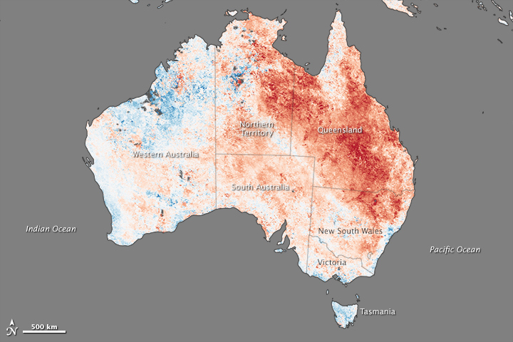
2013 turned out to be Australia’s hottest year on record. Fittingly, the year both started and ended with intense heatwaves. The most recent heatwave peaked between December 27, 2013, and January 4, 2014. It was much shorter than the heatwave that began 2013, though it was more intense. Nearly 9 percent of Australia experienced record-breaking temperatures between January 1–4, 2014.
The heat baked the earth, raising the land surface temperatures (LSTs) monitored by the Moderate Resolution Imaging Spectroradiometer (MODIS) on NASA’s Terra satellite. Dark red dominates this image, indicating that temperatures were significantly higher than average between December 27 and January 3, especially in Queensland and New South Wales. LSTs reflect how warm the ground would be to the touch, a measurement related to but not the same as more standard air temperatures.
The final day included in the image, January 3, was the hottest day of the heatwave for most places, with 10.2 percent of Queensland and 14.6 percent of New South Wales setting new heat records. The highest air temperature recorded during the week was in Moomba, Queensland, which reached 49.3 degrees Celsius (120.7 degrees Fahrenheit) on January 2. Temperatures reached 48 degrees Celsius (118 Fahrenheit) or higher at 12 locations throughout Australia during the heatwave.
-
Reference
- Australian Government Bureau of Meteorology (2013, January 6) Special climate statement 47 – an intense heatwave in central and eastern Australia. Accessed January 7, 2014.
NASA Earth Observatory image by Jesse Allen, using data from the Level 1 and Atmospheres Active Distribution System
